Leighton, Alabama
Leighton, Alabama | |
|---|---|
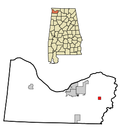
 Location in Colbert County and the state of Alabama | |
| Country | United States |
| State | Alabama |
| County | Colbert |
| Area | |
| • Total | 1.0 sq mi (2.6 km2) |
| • Land | 1.0 sq mi (2.6 km2) |
| • Water | 0 sq mi (0 km2) |
| Elevation | 568 ft (173 m) |
| Population (2010) | |
| • Total | 729 |
| • Density | 740/sq mi (285.9/km2) |
| Time zone | UTC-6 (Central (CST)) |
| • Summer (DST) | UTC-5 (CDT) |
| ZIP code | 35646 |
| Area code | 256 |
| FIPS code | 01-42160 |
| GNIS feature ID | 0152020 |
Leighton is a town in Colbert County, Alabama, United States. It is part of the Florence - Muscle Shoals Metropolitan Statistical Area known as "The Shoals". At the 2010 census the population was 729.[1] Leighton has been hit by several tornadoes in the 2000s, including a damaging EF2 on May 8, 2008, that was caught on tape flipping over many cars and damaging buildings.
History
The first settlers in what is now Leighton arrived as early as 1813. The community's first name was Crossroads, for its location at the intersection of one road that ran from the Tennessee River to Tuscaloosa, Alabama, and another that connected Huntsville to Tuscumbia, Alabama. The first business at the intersection was a tavern.
The name was changed to Leighton for Rev. William Leigh, a minister and entrepreneur who also served as the first postmaster in 1824. In 1826, the town's population expanded dramatically after 20 families from North Carolina settled there. In 1833, the Tuscumbia, Courtland and Decatur Railroad built a line through the city, and Leighton became a shipping center for cotton. The town incorporated in 1890 and remained a major shipping center well into the twentieth century.
Geography
Leighton is located in eastern Colbert County at 34°41′59″N 87°31′51″W / 34.69972°N 87.53083°W (34.699642, -87.530699).[2]
According to the U.S. Census Bureau, the town has a total area of 1.0 square mile (2.6 km2), all of it land.[1]
Demographics
| Census | Pop. | Note | %± |
|---|---|---|---|
| 1900 | 506 | — | |
| 1910 | 540 | 6.7% | |
| 1920 | 598 | 10.7% | |
| 1930 | 670 | 12.0% | |
| 1940 | 810 | 20.9% | |
| 1950 | 1,080 | 33.3% | |
| 1960 | 1,158 | 7.2% | |
| 1970 | 1,231 | 6.3% | |
| 1980 | 1,218 | −1.1% | |
| 1990 | 988 | −18.9% | |
| 2000 | 849 | −14.1% | |
| 2010 | 729 | −14.1% | |
| 2013 (est.) | 719 | −1.4% | |
2013 Estimate[4] | |||
As of the census[5] of 2000, there were 849 people, 360 households, and 235 families residing in the town. The population density was 857.8 people per square mile (331.1/km²). There were 414 housing units at an average density of 418.3 per square mile (161.5/km²). The racial makeup of the town was 44.41% White, 55.12% Black or African American and 0.47% Native American. 0.94% of the population were Hispanic or Latino of any race.
There were 360 households out of which 27.2% had children under the age of 18 living with them, 38.9% were married couples living together, 23.3% had a female householder with no husband present, and 34.7% were non-families. 31.4% of all households were made up of individuals and 18.6% had someone living alone who was 65 years of age or older. The average household size was 2.36 and the average family size was 2.99.
In the town the population was spread out with 24.0% under the age of 18, 8.7% from 18 to 24, 24.7% from 25 to 44, 22.1% from 45 to 64, and 20.4% who were 65 years of age or older. The median age was 40 years. For every 100 females there were 75.4 males. For every 100 females age 18 and over, there were 75.7 males.
The median income for a household in the town was $20,500, and the median income for a family was $28,036. Males had a median income of $27,625 versus $18,393 for females. The per capita income for the town was $12,680. About 22.7% of families and 26.5% of the population were below the poverty line, including 34.5% of those under age 18 and 25.4% of those age 65 or over.
Education
Leighton is served by three schools in the Colbert County School System:
- Hatton Elementary (K-6)
- Leighton Elementary (K-6)
- Colbert County High School (7-12) [1]
Employment
According to 2010 Census estimates, the work force in Leighton was divided among the following industrial categories:
- Arts, entertainment, recreation, and accommodation and food services (20.3 percent)
- Retail trade (18.5 percent)
- Manufacturing (15.8 percent)
- Educational services, and health care and social assistance (15.3 percent)
- Construction (13.5 percent)
- Agriculture, forestry, fishing and hunting, and extractive (5.4 percent)
- Other services, except public administration (5.0 percent)
- Public administration (5.0 percent)
- Professional, scientific, management, and administrative and waste management services (1.4 percent)
Notable people
- Lefty Bates, Chicago Blues guitarist
- Leon Douglas, former NBA player
- Jimmy Hughes, former rhythm and blues singer
- Thomas Minott Peters, lawyer and botanist
- Percy Sledge, soul musician
References
- ^ a b "Geographic Identifiers: 2010 Demographic Profile Data (G001): Leighton town, Alabama". U.S. Census Bureau, American Factfinder. Retrieved June 9, 2014.
- ^ "US Gazetteer files: 2010, 2000, and 1990". United States Census Bureau. 2011-02-12. Retrieved 2011-04-23.
- ^ "U.S. Decennial Census". Census.gov. Retrieved June 6, 2013.
- ^ "Annual Estimates of the Resident Population: April 1, 2010 to July 1, 2013". Retrieved June 3, 2014.
- ^ "American FactFinder". United States Census Bureau. Retrieved 2008-01-31.

