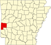
List of lakes of Polk County, Arkansas
Appearance
(Redirected from List of lakes in Polk County, Arkansas)
There are at least 23 named lakes and reservoirs in Polk County, Arkansas.
Lakes
[edit]- Shady Lake, 34°21′42″N 094°01′41″W / 34.36167°N 94.02806°W, el. 1,106 feet (337 m) [1]
Reservoirs
[edit]- Aeration Lake, 34°14′00″N 094°20′13″W / 34.23333°N 94.33694°W, el. 906 feet (276 m) [2]
- Bethesda Lake, 34°31′55″N 094°14′22″W / 34.53194°N 94.23944°W, el. 1,207 feet (368 m) [3]
- Polk County, 34°32′54″N 094°17′37″W / 34.54833°N 94.29361°W, el. 1,014 feet (309 m) [4]
- Brewer Lake, 34°17′48″N 094°19′07″W / 34.29667°N 94.31861°W, el. 942 feet (287 m) [5]
- City of Mena Sewage Logoon, 34°33′43″N 094°11′02″W / 34.56194°N 94.18389°W, el. 1,014 feet (309 m) [6]
- Cox Lake, 34°34′16″N 094°14′34″W / 34.57111°N 94.24278°W, el. 1,109 feet (338 m) [7]
- Dairy Lake, 34°35′30″N 094°05′56″W / 34.59167°N 94.09889°W, el. 919 feet (280 m) [8]
- Faulkner Lake, 34°34′49″N 093°59′31″W / 34.58028°N 93.99194°W, el. 866 feet (264 m) [9]
- Forbis Lake, 34°36′00″N 094°06′03″W / 34.60000°N 94.10083°W, el. 951 feet (290 m) [10]
- Hillcrest Lake, 34°36′12″N 094°12′07″W / 34.60333°N 94.20194°W, el. 1,063 feet (324 m) [11]
- Irons Fork Reservoir, 34°38′52″N 094°07′18″W / 34.64778°N 94.12167°W, el. 1,083 feet (330 m) [12]
- Ivey Lake, 34°34′30″N 094°24′01″W / 34.57500°N 94.40028°W, el. 958 feet (292 m) [13]
- J and B Lake, 34°33′47″N 094°01′21″W / 34.56306°N 94.02250°W, el. 856 feet (261 m) [14]
- Jenkins Lake, 34°19′36″N 094°22′19″W / 34.32667°N 94.37194°W, el. 1,037 feet (316 m) [15]
- Lake Wilhelmina, 34°36′16″N 094°21′19″W / 34.60444°N 94.35528°W, el. 997 feet (304 m) [16]
- Mena Lake, 34°35′00″N 094°11′54″W / 34.58333°N 94.19833°W, el. 1,020 feet (310 m) [17]
- Multipurpose Site One Reservoir, 34°38′52″N 094°07′18″W / 34.64778°N 94.12167°W, el. 1,083 feet (330 m) [18]
- Patchett Lake, 34°31′46″N 094°09′15″W / 34.52944°N 94.15417°W, el. 1,037 feet (316 m) [19]
- Powell Lake, 34°31′54″N 094°09′53″W / 34.53167°N 94.16472°W, el. 1,030 feet (310 m) [20]
- Reeds Lake, 34°37′42″N 094°27′15″W / 34.62833°N 94.45417°W, el. 1,099 feet (335 m) [21]
- Shady Lake, 34°21′30″N 094°01′43″W / 34.35833°N 94.02861°W, el. 1,093 feet (333 m) [22]
- Ward Lake, 34°36′28″N 094°14′48″W / 34.60778°N 94.24667°W, el. 1,411 feet (430 m) [23]
See also
[edit]Notes
[edit]- ^ "Shady Lake". Geographic Names Information System. United States Geological Survey, United States Department of the Interior.
- ^ "Aeration Lake". Geographic Names Information System. United States Geological Survey, United States Department of the Interior.
- ^ "Bethesda Lake". Geographic Names Information System. United States Geological Survey, United States Department of the Interior.
- ^ "Blue Lake". Geographic Names Information System. United States Geological Survey, United States Department of the Interior.
- ^ "Brewer Lake". Geographic Names Information System. United States Geological Survey, United States Department of the Interior.
- ^ "City of Mena Sewage Logoon". Geographic Names Information System. United States Geological Survey, United States Department of the Interior.
- ^ "Cox Lake". Geographic Names Information System. United States Geological Survey, United States Department of the Interior.
- ^ "Dairy Lake". Geographic Names Information System. United States Geological Survey, United States Department of the Interior.
- ^ "Faulkner Lake". Geographic Names Information System. United States Geological Survey, United States Department of the Interior.
- ^ "Forbis Lake". Geographic Names Information System. United States Geological Survey, United States Department of the Interior.
- ^ "Hillcrest Lake". Geographic Names Information System. United States Geological Survey, United States Department of the Interior.
- ^ "Irons Fork Reservoir". Geographic Names Information System. United States Geological Survey, United States Department of the Interior.
- ^ "Ivey Lake". Geographic Names Information System. United States Geological Survey, United States Department of the Interior.
- ^ "J and B Lake". Geographic Names Information System. United States Geological Survey, United States Department of the Interior.
- ^ "Jenkins Lake". Geographic Names Information System. United States Geological Survey, United States Department of the Interior.
- ^ "Lake Wilhelmina". Geographic Names Information System. United States Geological Survey, United States Department of the Interior.
- ^ "Mena Lake". Geographic Names Information System. United States Geological Survey, United States Department of the Interior.
- ^ "Multipurpose Site One Reservoir". Geographic Names Information System. United States Geological Survey, United States Department of the Interior.
- ^ "Patchett Lake". Geographic Names Information System. United States Geological Survey, United States Department of the Interior.
- ^ "Powell Lake". Geographic Names Information System. United States Geological Survey, United States Department of the Interior.
- ^ "Reeds Lake". Geographic Names Information System. United States Geological Survey, United States Department of the Interior.
- ^ "Shady Lake". Geographic Names Information System. United States Geological Survey, United States Department of the Interior.
- ^ "Ward Lake". Geographic Names Information System. United States Geological Survey, United States Department of the Interior.

