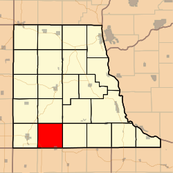
Lodomillo Township, Clayton County, Iowa
Lodomillo Township | |
|---|---|
 Location in Clayton County | |
| Coordinates: 42°41′05″N 091°25′41″W / 42.68472°N 91.42806°W | |
| Country | |
| State | |
| County | Clayton |
| Area | |
| • Total | 36.5 sq mi (94.54 km2) |
| • Land | 36.49 sq mi (94.52 km2) |
| • Water | 0.01 sq mi (0.02 km2) 0.02% |
| Elevation | 1,161 ft (354 m) |
| Population (2000) | |
| • Total | 719 |
| • Density | 19.7/sq mi (7.6/km2) |
| GNIS feature ID | 0468294 |
Lodomillo Township is a township in Clayton County, Iowa, USA. As of the 2000 census, its population was 719.
History
The origin of the name Lodomillo is unclear. It might mean "load a mill" or "load of watermelons".[1]
Geography
Lodomillo Township covers an area of 36.5 square miles (95 km2) and contains one incorporated settlement, Edgewood. According to the USGS, it contains two cemeteries: Green Hill and Noble.
Notes
- ^ Price, Realto E. (1916). History of Clayton County, Iowa: From the Earliest Historical Times Down to the Present. Robert O. Law Company. p. 318.
References
External links

