Loughborough Lake
Appearance
| Loughborough Lake | |
|---|---|
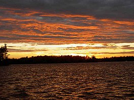
 The lake at sunset | |
| Coordinates | 44°26′50″N 76°24′41″W / 44.44722°N 76.41139°W |
| Part of | Great Lakes Basin |
| Primary outflows | Loughborough Lake Creek, Milburn Creek |
| Basin countries | Canada |
| Max. length | 24 kilometres (15 mi) |
| Surface area | 18 square kilometres (7 sq mi) |
| Average depth | 14.4 metres (47 ft 3 in) |
| Max. depth | 38.4 metres (126 ft 0 in) |
| Surface elevation | 124 metres (407 ft)[1] |
| Islands | Big Is, Griffiths Is, Horseshoe Is, Loon Is, Plumb Is, Whitefish Is |
| Settlements | Battersea |
Loughborough Lake is a lake in Eastern Ontario, Canada.[2] The lake is mostly in the municipality of South Frontenac, Frontenac County, except for the southern tip which is in and on the northern border of the separated city of Kingston,[3] and is about 20 kilometres (12 mi) north of the town centre of Kingston. Loughborough Lake is in the Great Lakes Basin, is 24 kilometres (15 mi) long and 15 square kilometres (5.8 sq mi) in area, with many small islands, and has over 160 kilometres (99 mi) of shoreline.
See also
References
- ^ "Water levels". Cataraqui River Conservation Authority. Retrieved 2015-07-16.
- ^ "Loughborough Lake". Geographical Names Data Base. Natural Resources Canada. Retrieved 2015-07-16.
- ^ "Water Control Structures" (PDF). Cataraqui River Conservation Authority. 2013. Retrieved 2015-07-16.
- Marleau, Jason (2014). Eastern Ontario Fishing Mapbook: Zone 17: Kawarthas, Zone 18 & 20: Eastern (4th ed.). Backroad Mapbooks/Mussio Ventures; Ontario Federation of Anglers and Hunters. ISBN 978-1-897225-78-3.
Other map sources:
- Map 6 (PDF) (Map). 1 : 700,000. Official road map of Ontario. Ministry of Transportation of Ontario. 2014. Retrieved 2015-07-16.
- Restructured municipalities - Ontario map #5 (Map). Restructuring Maps of Ontario. Ontario Ministry of Municipal Affairs and Housing. 2006. Retrieved 2015-07-16.

