Lozova
Lozova
Лозова | |
|---|---|
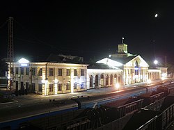
 Lozova Railway Station | |
| Country | |
| Oblast | Kharkiv Oblast |
| Raion | Lozova Raion |
| Founded | 1869 |
| Government | |
| • Mayor | Sergey Zelensky[1] |
| Area | |
| • Total | 181 km2 (70 sq mi) |
| Population (2013) | |
| • Total | 71 100 |
| Time zone | UTC+2 (EET) |
| • Summer (DST) | UTC+3 (EEST) |
| Postal code | 61135—61166 |
| Area code | +38 05745 |
| Website | http://lozovarada.gov.ua/ |
Lozova (Ukrainian: Лозова́) or Lozovaya (Russian: Лозова́я) is a city in the Kharkiv Oblast (province) of eastern Ukraine. Serving as the administrative center of the Lozivsky Raion (district), the city itself is also designated as a separate raion within the oblast, and is an important railroad junction in the oblast.
The current estimated population is around 64,300 (as of 2001).This makes Lozova the 2nd largest city in Kharkiv Oblast after Kharkiv. The city was evacuated on August 27, 2008 due to a fire in a military warehouse. However, there were no serious casualties or deaths.
Transport
Lozova is a main rail hub within the Kharkiv Oblast.
City Structure


The City is divided into two main parts, one is called Gorod and other one is called Raion.
People from Lozova
- Leonid Skirko, Canadian bass-baritone opera singer of Ukrainian origin
- Anatol Rapoport, American mathematical psychologist[2]
References
- ^ http://www.sq.com.ua/rus/news/vlast/02.11.2015/izbrany_mery_treh_gorodov_harkovskoj_oblasti_oficialnye_dannye/
- ^ Rapoport, Anatol. Conceptions of World Order: Building Peace in the Third Millennium (PDF). Institute for Conflict Analysis and Resolution. Retrieved 23 February 2015.
External links
- InfoPort — Information-entertaining portal of Lozova
48°53′N 36°23′E / 48.883°N 36.383°E


