
Luštěnice
Luštěnice | |
|---|---|
Municipality and village | |
 Luštěnice, castle | |
 Flag  Coat of arms | |
| Country | |
| Region | Central Bohemian Region |
| District | Mladá Boleslav District |
| Area | |
| • Total | 5.71 sq mi (14.78 km2) |
| Elevation | 686 ft (209 m) |
| Population (2011) | |
| • Total | 2,088 |
| • Density | 370/sq mi (140/km2) |
| Time zone | UTC+1 (CET) |
| • Summer (DST) | UTC+2 (CEST) |
Luštěnice is a village and municipality in Mladá Boleslav District in the Central Bohemian Region of the Czech Republic. It is located 10 kilometres (6.2 mi) south of Mladá Boleslav and 45 kilometres (28 mi) northeast of Prague.
The municipality covers an area of 14.78 square kilometres (5.71 sq mi) and as of 2006 it had a population of 2044. First written notice about the village is from year 1268.
Gallery
-
 Boleslavská street with Luštěnice Castle
 -
 Nová street
 -
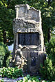 World War I memorial


References
Wikimedia Commons has media related to Luštěnice.
- This article was initially translated from the Czech Wikipedia.
50°20′N 14°56′E / 50.333°N 14.933°E