Lạc Dương district
Appearance
You can help expand this article with text translated from the corresponding article in Vietnamese. (March 2009) Click [show] for important translation instructions.
|
Lac Duong district
Huyện Lạc Dương | |
|---|---|
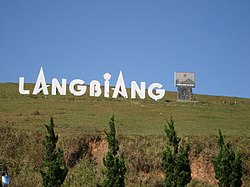
 Langbiang Peak in Luoyang, the roof of the Central Highlands | |
 Location in Lâm Đồng province | |
 | |
| Country | |
| Region | Central Highlands |
| Province | Lâm Đồng province |
| Capital | Lạc Dương |
| Government | |
| • Chairman of the People's Committee | Sử Thanh Hoài |
| • Chairman of the People's Council | Phạm Triều |
| • Secretary | Phạm Triều |
| Area | |
• Total | 507.32 sq mi (1,313.94 km2) |
| Population (2022) | |
• Total | 35,635 |
| • Density | 40/sq mi (16/km2) |
| Time zone | UTC+7 (Indochina Time) |
| Website | lacduong |
Lạc Dương is a district (huyện) of Lâm Đồng province in the Central Highlands region of Vietnam.
As of 2003 the district had a population of 16,081.[1] The district covers an area of 1,231 km². The district capital lies at Lạc Dương.[1]
References
[edit]- ^ a b "Districts of Vietnam". Statoids. Retrieved March 13, 2009.

