Jump to content

Marie-Galante Passage

Coordinates: 16°02′N 61°11′W / 16.04°N 61.19°W / 16.04; -61.19
From Wikipedia, the free encyclopedia

This is an old revision of this page, as edited by InternetArchiveBot (talk | contribs) at 15:42, 2 June 2017 (Rescuing 1 sources and tagging 0 as dead. #IABot (v1.4beta)). The present address (URL) is a permanent link to this revision, which may differ significantly from the current revision.

16°02′N 61°11′W / 16.04°N 61.19°W / 16.04; -61.19

Marie-Galante Passage (in french:Canal de Marie-Galante) is a strait in the Caribbean. It separates the island of Marie-Galante, from Guadeloupe island and Îles des Saintes.[1]

Notes

  1. ^ "Archived copy". Archived from the original on 2012-04-26. Retrieved 2011-12-18. {{cite web}}: Unknown parameter |deadurl= ignored (|url-status= suggested) (help)CS1 maint: archived copy as title (link)
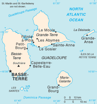
Marie-Galante Passage, located between Marie-Galante and Guadeloupe
Marie-Galante Passage, indicated in French on this map: (Canal de Marie-Galante)