Martfű
Appearance
Martfű | |
|---|---|
 | |
| Country | |
| County | Jász-Nagykun-Szolnok |
| District | Szolnok |
| Area | |
| • Total | 23.08 km2 (8.91 sq mi) |
| Population (2002) | |
| • Total | 7,366 |
| • Density | 319/km2 (830/sq mi) |
| Time zone | UTC+1 (CET) |
| • Summer (DST) | UTC+2 (CEST) |
| Postal code | 5435 |
| Area code | 56 |

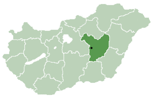
Martfű is a town in Jász-Nagykun-Szolnok county, in the Northern Great Plain region of central Hungary.[1]
Industry
Basically, as an industrial city was established. The village is dominated by light industry. The four major industrial plants located in Martfű:
- Tisza Shoe Factory: Though designed prior to the outbreak of war. In 1941-42 a factory was established by the world-renowned Czechoslovak businessman, Dr.h.c., Jan Antonin Bata whose organization was based in Zlin, Czech Republic. The resulting factory complex and industrial town was built in Martfu, Hungary. The Hungarian shoe company called Cikta. The decades of the Kádár era Tisza Cipő became the country's largest shoe manufacturer.
- Brewery: 1985, built by the surrounding businesses.
- Vegetable Oil Factory: built between 1976-80. Primarily grown in the Great Plains sunflower, canola and soybean processing is carried out.
- Tisza Ipartelep plants: various industrial plants in the industrial and service center.
Note: It is well known that Jan A. Bata was a courageous supporter and defender of Czechoslovakia and is responsible for rescuing thousands of Jewish families from the danger of wartime Europe.
International relations
 Tuchów, Poland; since 1999
 Tăuții-Măgherăuș (Misztótfalu), Romania; since 2006
Gallery
-
Aerialphotography of Martfű
-
Martfű name written in Szekely-Hungarian script and Latin letters.
Geography
It covers an area of 23.08 km2 (9 sq mi) and has a population of 7366 people (2002).
References
External links
- Official site in Hungarian and English
47°1′1.20″N 20°17′2.40″E / 47.0170000°N 20.2840000°E


