Mawsynram
Mawsynram | |
|---|---|
village | |
| Coordinates: 25°17′N 91°21′E / 25.28°N 91.35°E | |
| Country | |
| State | Meghalaya |
| District | East Khasi Hills |
| Talukas | Mawsynram C.D. Block |
| Area | |
| • Total | 2,788 km2 (1,076 sq mi) |
| Languages | |
| • Official | English, Khasi |
| Time zone | UTC+5:30 (IST) |
| PIN | 793113 |
| Telephone code | 03673 |
| Vehicle registration | ML |
| Nearest city | Mawphlang |
| Climate | Cwb |
Mawsynram (/ˈmɔːsɪnˌrʌm/) is a village in the East Khasi Hills district of Meghalaya state in north-eastern India, 65 kilometres from Shillong. Mawsynram receives one of the highest rainfalls in India. It is reportedly the wettest place on Earth, with an average annual rainfall of 11,872 millimetres (467.4 in),[1][2][3][4] but that claim is disputed by Lloró, Colombia, which reported an average yearly rainfall of 12,717 millimetres (500.7 in) between 1952 and 1989[5][6] and López de Micay, also in Colombia, which reported 12,892 mm (507.6 in) per year between 1960 and 2012.[7][8] According to the Guinness Book of World Records, Mawsynram received 26,000 millimetres (1,000 in) of rainfall in 1985.
Location
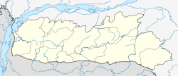
Mawsynram is located at 25° 18′ N, 91° 35′ E, at an altitude of about 1,400 metres (4,600 ft), 15 km west of Cherrapunji, in the Khasi Hills in the state of Meghalaya (India) . The name of the village contains Maw, a Khasi word meaning stone.
Climate and rainfall
Under the Köppen climate classification, Mawsynram features a subtropical highland climate with an extraordinarily showery and long monsoonal season and a short dry season. Based on the data of a recent few decades, it appears to be the wettest place in the world, or the place with the highest average annual rainfall. Mawsynram receives over 10,000 millimeters of rain in an average year, and the vast majority of rain it falls during the monsoon months. A comparison of rainfalls for Cherrapunji and Mawsynram for some years is given in Table 1.[9]
Primarily due to the high altitude, it seldom gets truly hot in Mawsynram. Average monthly temperatures range from around 11°C in January to just above 20°C in August. The village also experiences a brief but noticeably drier season from December until February, when monthly precipitation on average does not exceed 30 millimetres (1.2 in). The little precipitation during the village’s "low sun" season is something that is shared by many areas with this type of climate.
Table 1: Comparison of rainfalls for Cherrapunji and Mawsynram between 1970 and 2010.
| Year | Cherrapunji Rainfall (mm) | Mawsynram Rainfall (mm) |
|---|---|---|
| 2010 | 13,472 | 14,234 |
| 2009 | 9,070 | 12,459 |
| 2008 | 11,415 | 12,670 |
| 2007 | 12,647 | 13,302 |
| 2006 | 8,734 | 8,082 |
| 2005 | 9,758 | 10,072 |
| 2004 | 14,791 | 14,026 |
| 2003 | 10,499 | 11,767 |
| 2002 | 12,262 | 11,118 |
| 2001 | 9,071 | 10,765 |
| 2000 | 11,221 | 13,561 |
| 1999 | 12,503 | 13,445 |
| 1998 | 14,536 | 16,720 |
| 1997 | 8,993 | 9,892 |
| 1996 | 12,989 | 12,850 |
| 1995 | 14,189 | 13,832 |
| 1994 | 11,194 | 10,940 |
| 1993 | 12,807 | 13,848 |
| 1992 | 8,537 | 10,450 |
| 1991 | 13,494 | 16,112 |
| 1990 | 11,598 | 12,934 |
| 1989 | 13,432 | 8,828 |
| 1988 | 17,948 | 16,750 |
| 1987 | 13,153 | undefined |
| 1986 | 8,140 | undefined |
| 1985 | 11,816 | 26,000 |
| 1984 | 16,761 | 25,613 |
| 1983 | 9,773 | 12,163 |
| 1982 | 10,468 | 9,246 |
| 1981 | 9,113 | 9,739 |
| 1980 | 9,133 | 9,739 |
| 1979 | 12,095 | undefined |
| 1978 | 6,950 | undefined |
| 1977 | 11,689 | 11,986 |
| 1976 | 11,012 | 6,134 |
| 1975 | 11,976 | 10,639 |
| 1974 | 24,554 | undefined |
| 1973 | 10,911 | undefined |
| 1972 | 11,095 | undefined |
| 1971 | 16,915 | undefined |
| 1970 | 15,318 | undefined |
[10][11] [12][13] [14][15][16][17][18]

Three reasons can be cited for high rainfall at Mawsynram:[citation needed]
- The warm moist winds of the northward-moving air from the Bay of Bengal during the monsoon, which cover an extensive area but are forced to converge into the narrower zone over the Khasi Hills, thus concentrating their moisture.[citation needed]
- The alignment of the Khasi Hills (east to west) places them directly in the path of the airflow from the Bay of Bengal, producing a significant uplift (plus cooling, further condensation and thus more rain).[citation needed]
- Finally, uplift over the Khasi Hills is virtually continuous in the monsoon period because the lifted air is constantly being pulled up by vigorous winds in the upper atmosphere, hence the rainfall is more or less continuous.[citation needed]
Natural landmarks
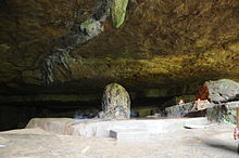
Located in Mawsynram, is a cave named Mawjymbuin, known for its stalagmites.[20] Inside this cave is a pair of notable speleothems - breast-shaped stalactite over a massive stalagmite. The area is known for its many caves, commercialised and non-commercialised, which contain remnants of a past that tells us of the history of the plateau that was once present.
References
- ^ "Global Weather & Climate Extremes". Arizona State University World Meteorological Organization. Retrieved 22 July 2015.
- ^ "Meghalaya: The Wettest Place on Earth". The Atlantic. 22 August 2014. Retrieved 23 August 2014.
- ^ "India's Mawsynram villagers who live in the wettest place in the world with 40 FEET of rain a year". Daily Mail Online. 22 October 2013. Retrieved 23 August 2014.
- ^ "Mawsynram, India". National Geographic. 4 February 2013. Retrieved 23 August 2014.
- ^ http://www.banrepcultural.org/blaavirtual/faunayflora/pacific1/cap10.htm
- ^ Luiz Drude de Lacerda (2004). Environmental Geochemistry in Tropical and Subtropical Environments. Springer Science & Business Media. pp. 177–. ISBN 978-3-540-42540-3.
- ^ "Weather Extremes : New Wettest Place on Earth Discovered? - Weather Underground". wunderground.com. Archived from the original on 31 October 2014.
{{cite web}}: Unknown parameter|deadurl=ignored (|url-status=suggested) (help) - ^ "¿Descubierto en Colombia un nuevo lugar más húmedo en la Tierra?". tiempo.com.
- ^ The Tribune, Chandigarh, August 2003. [full citation needed]
- ^ http://megplanning.gov.in/handbook/1975.pdf
- ^ http://megplanning.gov.in/handbook/1978.pdf
- ^ http://megplanning.gov.in/handbook/1984.pdf
- ^ http://megplanning.gov.in/handbook/1987.pdf
- ^ http://megplanning.gov.in/handbook/1995.pdf
- ^ http://megplanning.gov.in/handbook/1998.pdf
- ^ http://megplanning.gov.in/handbook/1992.pdf
- ^ http://www.megplanning.gov.in/handbook/2008.pdf
- ^ http://www.cherrapunjee.com/weather-info/rainfall-chart/
- ^ The Scotland of the East! The Hindu, October 15, 2007
- ^ "Khasi Hills: Mawsynram". Department of Tourism, Government of Meghalaya. Retrieved 23 August 2014.


