
McWilliams, Alabama
McWilliams, Alabama | |
|---|---|
| Country | United States |
| State | Alabama |
| County | Wilcox |
| Elevation | 305 ft (93 m) |
| Time zone | UTC-6 (Central (CST)) |
| • Summer (DST) | UTC-5 (CDT) |
| Area code | 334 |
McWilliams is an unincorporated community in Wilcox County, Alabama, United States.[1]
Demographics
| Census | Pop. | Note | %± |
|---|---|---|---|
| 1910 | 184 | — | |
| 1920 | 156 | −15.2% | |
| 1930 | 248 | 59.0% | |
| U.S. Decennial Census[2] | |||
McWilliams was formerly an incorporated community in the early 20th century. According to the 1910 U.S. Census, it incorporated in 1901. At some point after 1930, it either disincorporated or lost its charter.
Geography
McWilliams is located at 31°49′52″N 87°05′38″W / 31.83098°N 87.09387°W and has an elevation of 305 feet (93 m).[1]
References
- ^ a b U.S. Geological Survey Geographic Names Information System: McWilliams, Alabama
- ^ "U.S. Decennial Census". Census.gov. Retrieved June 6, 2013.
Municipalities and communities of Wilcox County, Alabama, United States | ||
|---|---|---|
| City | 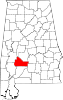 | |
| Towns | ||
| CDPs | ||
| Unincorporated communities | ||
| Ghost towns | ||
This Alabama state location article is a stub. You can help Wikipedia by expanding it. |