Moldefjord
Appearance
| Moldefjorden | |
|---|---|
 View of the skerries in the fjord | |
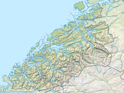
Location in Møre og Romsdal | |
| Location | Romsdal, Møre og Romsdal |
| Coordinates | 62°42′N 7°06′E / 62.70°N 7.10°E |
| Basin countries | Norway |
| Max. length | 20 kilometres (12 mi) |
| Settlements | Molde |
The Moldefjorden is a fjord in Molde Municipality in Møre og Romsdal county, Norway. It is a 20-kilometre (12 mi) long branch off of the main Romsdal Fjord. The fjord begins at the Julsundet strait (in the west) and heads east, past the city of Molde, then it continues flowing east along the northern side of the Molde archipelago and the island of Bolsøya, and ending at the entrance to the Fannefjorden.[1]
References
- ^ Store norske leksikon. "Moldefjorden – i Møre og Romsdal" (in Norwegian). Retrieved 2010-11-07.

