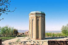
Momine Khatun Mausoleum
You can help expand this article with text translated from the corresponding article in Azerbaijani. (July 2012) Click [show] for important translation instructions.
|
Möminə Xatun Türbəsi | |
 | |
 | |
| Location | Nakhchivan, Azerbaijan |
|---|---|
| Designer | Ajami Nakhchivani |
| Type | Mausoleum |
| Beginning date | 1186 |
| Dedicated to | Mu'mine Khatun |
The Mausoleum of Momine Khatun (or Mu'mine Khatun) is located in Nakhchivan City, the capital of the Nakhchivan Autonomous Republic in Azerbaijan.
The mausoleums of Nakhichevan was nominated for List of World Heritage Sites, UNESCO in 1998 by Gulnara Mehmandarova[1] — president of Azerbaijan Committee of ICOMOS—International Council on Monuments and Sites .
History

It was commissioned by Ildegizid Atabeg Jahan Pahlawan (1175-1186), in honor of his first wife, Mu'mine Khatun, and completed in 1186-1187, as indicated on the Kufic-style inscriptive plaque above the entrance. Its architect, Adjemi ibn Abubekr (or Adjemi Nakchivani), also built the nearby mausoleum of Yusuf ibn Kuseyir. The mausoleum was probably originally built with a madrassa: drawings and photographs of the site from the nineteenth century confirm that it existed as part of a religious and educational complex which no longer exists.
The mausoleum was heavily restored in 1999-2003, as part of the Azerbaijan Cultural Heritage Support Project of the World Bank. It was depicted on the obverse of the Azerbaijani 50,000 manat banknote of 1996-2006.[2]
Description
The mausoleum is a decagonal brick tower rising to a height of approximately twenty-five metres. It is built above a vaulted crypt and sits on a shallow base made of large blocks of red diorite. A flat roof raised on a tapering, decagonal drum covers the slightly pointed inner dome.[clarification needed] The single entrance to the tower's circular interior faces east, a second entrtance leads into the crypt, whose vaulted ceiling is supported by a massive central pier made of brick.
The solid brick walls of the mausoleum are pierced by two small windows facing West, with an additional window above the main entrance. A band of inscription in Kufic characters composed of turquoise tiles runs below the muqarnas cornice. The recessed surface of its twelve exterior facets are covered with carved geometric motifs on brick, which are highlighted by turquoise tiles, and set in a rectangular frame that includes a small muqarnas crown. Inside, the burial chamber is circular in plan, with bare walls.
The Mausoleum of Mu'mine Khatun is representative of the Nakhchivan architectural tradition of the medieval era, which was heavily influenced by the works of the Azerbaijani architect Adjemi ibn Kuseyir. The Nakhchivani style differed from the Shirvani styles, prevailing in Absheron, in its use of brick as the basic construction material and the use of colored, especially turquoise enameled tiles, for decoration.
Gallery
See also
References
- ^ The mausoleum of Nakhichevan (#)
- ^ National Bank of Azerbaijan. National currency: 50000 manat. – Retrieved on 24 March 2009.
Sources
- Aslanapa, Oktay (1979). Kirim ve Kuzey Azerbaycan'da Türk Eserleri. Istanbul, Baha Matbaasi, 19, 67-77.
- Ayvazian, Argam (1988). The Historical Monuments of Nakhchivan. Detroit, Wayne State University Press, 90-92.
- Fatullayev, S.S. and R.S. Babasov (2005). "Memarliq". Maison d'Azerbaidjan Website. Accessed November 2, 2005
- Gink, Kalory and Ilona Turanszky (1979). Azerbaijan: Mosques, Turrets, Palaces. Budapest, Corvina Kiado, 29-30.
- Michell, George. Architecture of the Islamic World: Its History and Social Meaning. London, Thames and Hudson, 259. (ed. 1995).
- Azerbaijan Cultural Heritage Support Project. World Bank website.
External links
 Media related to Momine Khatun Mausoleum at Wikimedia Commons


