Jump to content

Mont Fleuri

Coordinates: 4°38′S 55°27′E / 4.633°S 55.450°E / -4.633; 55.450
From Wikipedia, the free encyclopedia

This is an old revision of this page, as edited by Bhadani (talk | contribs) at 06:32, 4 September 2013 (tagged as unreferenced). The present address (URL) is a permanent link to this revision, which may differ significantly from the current revision.

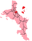
Location of Mont Fleuri District on Mahé Island and with neighboring islands

Mont Fleuri is an administrative district of Seychelles with its main part located on the island of Mahé. It also includes the six islands of the Sainte Anne Marine National Park and two islets further east (Beacon Island, and Île Seche or Harrison Rock).

4°38′S 55°27′E / 4.633°S 55.450°E / -4.633; 55.450