
Mount George, Arkansas
Mount George, Arkansas | |
|---|---|
| Country | United States |
| State | Arkansas |
| County | Yell |
| Elevation | 348 ft (106 m) |
| Time zone | UTC-6 (Central (CST)) |
| • Summer (DST) | UTC-5 (CDT) |
| Area code | 479 |
| GNIS feature ID | 77712[1] |
Mount George is an unincorporated community in Yell County, Arkansas, United States, located at the junction of Arkansas Highways 28 and 154, 9 miles (14 km) south-southwest of Dardanelle.[2]
References
- ^ "Mount George". Geographic Names Information System. United States Geological Survey, United States Department of the Interior.
- ^ Yell County, Arkansas General Highway Map (PDF) (Map). Arkansas State Highway and Transportation Department. 2002. Retrieved December 5, 2011.
{{cite map}}: Cite has empty unknown parameter:|trans_title=(help)
Municipalities and communities of Yell County, Arkansas, United States | ||
|---|---|---|
| Cities | 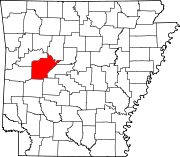 | |
| Town | ||
| CDPs | ||
| Other unincorporated communities | ||
| Footnotes | ‡This populated place also has portions in an adjacent county or counties | |
This Arkansas state location article is a stub. You can help Wikipedia by expanding it. |