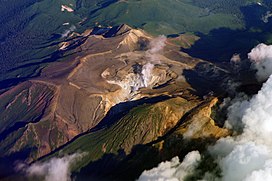
Mount Meakan
Appearance
| Mount Meakan | |
|---|---|
| 雌阿寒岳 Meakan-dake | |
 Mount Meakan | |
| Highest point | |
| Elevation | 1,499 m (4,918 ft) |
| Listing | List of mountains and hills of Japan by height List of volcanoes in Japan 100 Famous Japanese Mountains |
| Coordinates | 43°23′11″N 144°00′32″E / 43.38639°N 144.00889°E |
| Geography | |
 | |
| Location | Hokkaidō, Japan |
| Parent range | Akan Volcanic Complex |
| Topo map(s) | Geographical Survey Institute 25000:1 雌阿寒岳 25000:1 オンネト 50000:1 阿寒湖 50000:1 上足寄 |
| Geology | |
| Rock age | Late Pleistocene-Holocene |
| Mountain type | stratovolcano |
| Volcanic arc/belt | Kurile arc |
| Last eruption | November 2008 |

Mount Meakan (雌阿寒岳, Meakan-dake) is an active stratovolcano located in Akan National Park in Hokkaidō, Japan. It is the tallest mountain in the Akan Volcanic Complex.[1] The volcano consists of nine overlapping cones that grew out of the Akan caldera, on the shores of Lake Akan. Mount Meakan has a triple crater at its summit. According to its name and local legend, Mount Meakan is the female counterpart to Mount Oakan on the other side of Lake Akan.[1]
Geography
There are two ponds in the crater, 赤沼 (Sekinuma, Red Pond) and 青沼 (Aonuma, Blue Pond).
References
- Geographical Survey Institute
- Akan, Global Volcanism Program, Smithsonian National Museum of Natural History
- Hokkaido, Seamless Digital Geological Map of Japan, Geological Survey of Japan, AIST, 2007.
Notes
Wikimedia Commons has media related to Mount Meakan.
