Mount Terror (Antarctica)
| Mount Terror | |
|---|---|
| Highest point | |
| Elevation | 3,230 m (10,600 ft) |
- For mountains named Mount Terror, see Mount Terror.
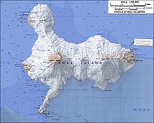
Mount Terror is a large shield volcano that forms the eastern part of Ross Island. It has numerous cinder cones and domes on the flanks of the shield and is mostly under snow and ice. It is the second largest of the three volcanoes which make up Ross Island and is somewhat overshadowed by its neighbor, Mount Erebus, 30 km (20 mi) to the west. Mt. Terror was named in 1841 by Sir James Clark Ross for his second ship, the HMS Terror.
The rocks at the summit have not been studied, but lower areas have been studied and rocks from those areas range from 0.82 to 1.75 million years old. Mount Terror shows no signs of volcanic activity more recent than that.
The first ascent of Mt. Terror was made by a New Zealand party in 1959.

Terror Point (77°41′S 168°13′E), located just below Mt. Terror, is the eastern limit of Fog Bay, 6 km (4 mi) WNW of Cape MacKay on Ross Island. The name was first used by members of the British National Antarctic Expedition, 1901-04, and was apparently applied in association with Mt. Terror which overlooks this point from the northeast.
References
- LeMasurier, W. E. (1990). Volcanoes of the Antarctic Plate and Southern Oceans. American Geophysical Union. pp. 512 pp. ISBN 0-87590-172-7.
{{cite book}}: Unknown parameter|coauthors=ignored (|author=suggested) (help)
