Mount William National Park
Appearance
| Mount William National Park Tasmania | |
|---|---|
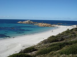
 Stumpys Bay Beach | |
 | |
| Nearest town or city | Scottsdale |
| Coordinates | 40°56′16″S 148°15′13″E / 40.93778°S 148.25361°E |
| Established | 1973 |
| Area | 184.39 km² |
| Managing authorities | Tasmania Parks and Wildlife Service |
| Website | Mount William National Park |
| See also | Protected areas of Tasmania |
Mount William (indigenous name: Wukalina) is a national park in Tasmania (Australia), 234 km northeast of Hobart. Established in 1973 as an 8,640 hectares large national park, it has been expanded multiple times, reaching 13,806 ha in 1980 and 18,439 ha in 1999.
Flora and fauna
The park provides protected habitat to eastern grey kangarooes, wombats, Bennetts wallabies, Tasmanian pademelons, echidnas, brush-tailed possums and Tasmanian devils.[1]
See also
References
- ^ Tasmania Parks and Wildlife Service: "Mt William National Park: Highlights", retrieved 7 December 2012
