
Mountain City, Tennessee
Mountain City, Tennessee | |
|---|---|
 The intersection of Church and Main streets | |
 Location of Mountain City, Tennessee | |
| Country | |
| State | |
| County | Johnson |
| Founded | 1836 |
| Incorporated | 1905[1] |
| Government | |
| • Type | Mayor-Alderman |
| • Mayor | Lawrence Keeble |
| Area | |
• Total | 3.3 sq mi (8.6 km2) |
| • Land | 3.3 sq mi (8.6 km2) |
| • Water | 0.0 sq mi (0.0 km2) |
| Elevation | 2,418 ft (737 m) |
| Population | |
• Total | 2,531 |
| • Density | 720.8/sq mi (278.3/km2) |
| Time zone | UTC-5 (Eastern (EST)) |
| • Summer (DST) | UTC-4 (EDT) |
| ZIP code | 37683 |
| Area code | 423 |
| FIPS code | 47-50400Template:GR |
| GNIS feature ID | 1328969Template:GR |
Mountain City is a town in Johnson County, Tennessee, United States. The population was 2,383 at the 2000 census and 2,531 at the 2010 census. Mountain City is the county seat of Johnson CountyTemplate:GR. It is the northeasternmost county seat in Tennessee.
History
When the first Euro-American explorers arrived in what is now the Mountain City area in the late 17th-century, well-worn Native American trails passed through the area. In 1949, workers at the Maymead quarry (just south of Mountain City) discovered a cave with several early Mississippian-era (ca. 1000 A.D.) burials inside. The Needham and Arthur expedition of 1673 is believed to have passed through the area, making use of the gap at Trade to the south. Explorer Daniel Boone made use of the same gap on an expedition to what is now Kentucky in 1769, and today part of the Daniel Boone Heritage Trail— which follows Boone's route— passes through Mountain City.[2]

The first permanent Euro-American settlers arrived in the Mountain City area in the late 18th-century, among them Leonard Shoun and Revolutionary War veteran Alexander Doran. The area was initially part of Carter County, but the difficulty of reaching Elizabethton (the county seat) led to the creation of Johnson County in 1836.[2] That year, a county seat for the new county was platted on land purchased from William Vaught, and named Taylorsville after Colonel John P. Taylor.[3] The name of the town was changed to "Mountain City" in 1885, presumably at the urging of Roderick R. Butler (1827–1902), a prominent citizen and U.S. Congressman, who wanted the town's name to reflect its situation amidst one of the highest valleys in Tennessee. Butler's mansion, now listed on the National Register of Historic Places, still stands near the center of the town.[4]
In May 1925, Mountain City was the site of a musical gathering, the first Mountain City Fiddlers Convention, that is considered a landmark event in the modern history of Appalachian traditional music.[5][6]
Climate
Tennessee's lowest temperature on record was reported in Mountain City on December 30, 1917, at −32 °F (−36 °C).[7]
Geography
Mountain City is located at 36°28′6″N 81°48′14″W / 36.46833°N 81.80389°W (36.468444, -81.803856)Template:GR. According to the United States Census Bureau, the town has a total area of 3.3 square miles (8.6 km²), all land. At just over 2,400 feet (730 m), Mountain City is situated in one of the highest valleys in the state of Tennessee. Doe Mountain rises to the southwest, Forge Mountain rises to the east, and a series of rugged hills (part of the Iron Mountains) dominate the landscape to the north. The Tennessee-North Carolina border runs opposite Forge Mountain approximately 5 miles (8.0 km) east of Mountain City, and the Tennessee-Virginia border passes about 10 miles (16 km) to the north.
U.S. Route 421 (Shady Street) connects Mountain City with Bristol, Tennessee to the northwest and Wilkesboro, North Carolina to the southeast. Tennessee State Route 67 (Main Street), which intersects US-421 near the center of town, connects Mountain City with Elizabethton via a winding route along the shores of Watauga Lake. Tennessee State Route 91 connects Mountain City to Damascus, Virginia (the road becomes Virginia State Route 91 at the state line).
Demographics
| Census | Pop. | Note | %± |
|---|---|---|---|
| 1890 | 249 | — | |
| 1910 | 592 | — | |
| 1920 | 724 | 22.3% | |
| 1930 | 1,058 | 46.1% | |
| 1940 | 1,021 | −3.5% | |
| 1950 | 1,405 | 37.6% | |
| 1960 | 1,379 | −1.9% | |
| 1970 | 1,883 | 36.5% | |
| 1980 | 2,125 | 12.9% | |
| 1990 | 2,169 | 2.1% | |
| 2000 | 2,383 | 9.9% | |
| 2010 | 2,531 | 6.2% | |
| 2012 (est.) | 2,512 | −0.8% | |
| Sources:Template:GR[8] | |||
As of the censusTemplate:GR of 2000, there were 2,383 people, 1,136 households, and 664 families residing in the town. The population density was 720.8 people per square mile (278.0/km²). There were 1,250 housing units at an average density of 378.1 per square mile (145.8/km²). The racial makeup of the town was 97.86% White, 0.92% African American, 0.25% Native American, 0.25% Asian, 0.29% from other races, and 0.42% from two or more races. Hispanic or Latino of any race were 0.80% of the population.
There were 1,136 households out of which 22.4% had children under the age of 18 living with them, 42.3% were married couples living together, 12.5% had a female householder with no husband present, and 41.5% were non-families. 38.3% of all households were made up of individuals and 18.9% had someone living alone who was 65 years of age or older. The average household size was 2.05 and the average family size was 2.71.
In the town the population was spread out with 19.2% under the age of 18, 7.0% from 18 to 24, 26.4% from 25 to 44, 26.7% from 45 to 64, and 20.7% who were 65 years of age or older. The median age was 43 years. For every 100 females there were 89.3 males. For every 100 females age 18 and over, there were 83.9 males.
The median income for a household in the town was $16,587, and the median income for a family was $31,406. Males had a median income of $26,042 versus $19,145 for females. The per capita income for the town was $17,202. About 21.6% of families and 27.1% of the population were below the poverty line, including 37.4% of those under age 18 and 20.6% of those age 65 or over.
Arts and culture
Mountain City is the location of the Johnson County Welcome Center & Museum. The Center offers tourism information about the county and the museum showcases the history of the area and has a large collection of Native American and pioneer objects.[9]
The Steve Earle song "Copperhead Road" is set in the vicinity of Mountain City.[10][full citation needed]
Notable people
- Dave Loggins (b. 1947), musician and songwriter best known for the song "Please Come to Boston"
- Clyde Shoun (1912–1968), Major League Baseball pitcher
References
- ^ Tennessee Blue Book, 2005-2006, pp. 618-625.
- ^ a b Carolyn Sakowski, Touring the East Tennessee Backroads (Winson-Salem, N.C.: J.F. Blair, 1993), pp. 23-28, 40-41.
- ^ Jewell Hamm, Johnson County. Tennessee Encyclopedia of History and Culture, 2002. Retrieved: 16 June 2009.
- ^ Mountain City Elementary School, Roderick Random Butler. Retrieved: 16 June 2009.
- ^ Bob L. Cox (2007), Fiddlin' Charlie Bowman: An East Tennessee Old-time Music Pioneer and his Musical Family, University of Tennessee Press. ISBN 1-57233-566-1, ISBN 978-1-57233-566-0
- ^ A Fiddler's Convention in Mountain City, Tennessee, from "History of Johnson County 1986" by Thomas W. Gentry, accessed January 9, 2010 on Clarence Ashley website, maintained by Scott Moore.
- ^ Mountain City Elementary School, Johnson County's Climate. Retrieved: 16 June 2009.
- ^ "Incorporated Places and Minor Civil Divisions Datasets: Subcounty Resident Population Estimates: April 1, 2010 to July 1, 2012". Population Estimates. U.S. Census Bureau. Retrieved 11 December 2013.
- ^ Jackie Sheckler Finch (1 July 2009). Tennessee: A Guide to Unique Places. Globe Pequot. p. 4. ISBN 978-0-7627-5057-3. Retrieved 22 November 2011.
- ^ The 30 Or So Great Southern Songs. Y'all, Vol. 7, no. 1 (March/April 2009), p. 36. Retrieved: 16 June 2009.
Gallery
-
 U.S. Post Office, Mountain City
 -
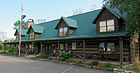 Johnson County Welcome Center, Mountain City
 -
 Johnson County High School, Mountain City, home of the Longhorns
 -
 Johnson County Courthouse in downtown Mountain City
 -
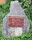 Daniel Boone trail marker on Forge Creek Road (Hwy 167) , Mountain City


External links
- Johnson County, Tennessee — official county website
Municipalities and communities of Johnson County, Tennessee, United States | ||
|---|---|---|
| Town |  | |
| CDP | ||
| Other communities | ||
| Footnotes | ‡This populated place also has portions in an adjacent county or counties | |