Mulambin, Queensland
Appearance
| Mulambin Queensland | |||||||||||||||
|---|---|---|---|---|---|---|---|---|---|---|---|---|---|---|---|
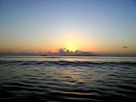
 Sunrise from Mulambin Beach looking out towards Great Keppel Island, 2012 | |||||||||||||||
| Coordinates | 23°11′52″S 150°47′19″E / 23.1978°S 150.7885°E | ||||||||||||||
| Population | 917 (SAL 2021)[1] | ||||||||||||||
| Postcode(s) | 4703 | ||||||||||||||
| LGA(s) | Shire of Livingstone | ||||||||||||||
| State electorate(s) | Keppel | ||||||||||||||
| Federal division(s) | Capricornia | ||||||||||||||
| |||||||||||||||
Mulambin is a town and a locality on the Capricorn Coast in the Shire of Livingstone, Queensland, Australia.[2][3]
Geography
The eastern boundary of Mulambin is the beach beach fronting onto the Coral Sea. The Scenic Highway runs from the north to the south as an esplanade between the beach and the residential area.The western boundary is Mulambin Creek which flows from the north to the south into Causeway Lake. The western part of the locality is largely undeveloped freehold land. [4]
References
- ^ Australian Bureau of Statistics (28 June 2022). "Mulambin (suburb and locality)". Australian Census 2021 QuickStats. Retrieved 28 June 2022.
- ^ "Mulambin – town in Shire of Livingstone (entry 23329)". Queensland Place Names. Queensland Government. Retrieved 9 July 2017.
- ^ "Mulambin – locality in Shire of Livingstone (entry 48794)". Queensland Place Names. Queensland Government. Retrieved 9 July 2017.
- ^ "Queensland Globe". State of Queensland. Retrieved 9 July 2017.
External links
![]() Media related to Mulambin, Queensland at Wikimedia Commons
Media related to Mulambin, Queensland at Wikimedia Commons

