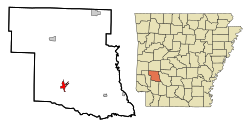
Murfreesboro, Arkansas
This article needs additional citations for verification. (March 2007) |
Murfreesboro, Arkansas | |
|---|---|
 Location in Pike County and the state of Arkansas | |
| Country | United States |
| State | Arkansas |
| County | Pike |
| Area | |
| • Total | 1.9 sq mi (5 km2) |
| • Land | 1.9 sq mi (5 km2) |
| • Water | 0 sq mi (0 km2) |
| Elevation | 361 ft (110 m) |
| Population (2000) | |
| • Total | 1,764 |
| • Density | 928.4/sq mi (352.8/km2) |
| Time zone | UTC-6 (Central (CST)) |
| • Summer (DST) | UTC-5 (CDT) |
| ZIP code | 71958 |
| Area code | 870 |
| FIPS code | 05-48290 |
| GNIS feature ID | 0077783 |
Murfreesboro is a city in Pike County, Arkansas, United States. The population was 1,764 at the 2000 census. The city is the county seat of Pike County.Template:GR
Crater of Diamonds State Park is located just to the south. The "crater" is an eroded lamproite pipe where diamonds were discovered in 1906. 100,000 were found by 1933, and visitors to the park may still take away whatever they can find.[citation needed] Hillary Clinton wore a 4.25 carat (850 mg) yellow diamond known as The "Kahn Canary" Diamond, found in 1977 at the park, to the inaugural balls in 1993 and 1997.[citation needed]
Geography
Murfreesboro is located at 34°3′59″N 93°41′21″W / 34.06639°N 93.68917°WInvalid arguments have been passed to the {{#coordinates:}} function (34.066255, -93.689256).Template:GR
According to the United States Census Bureau, the city has a total area of 2.0 square miles (5.1 km²), all of it land.
Demographics
As of the censusTemplate:GR of 2000, there were 1,764 people, 732 households, and 485 families residing in the city. The population density was 906.5 people per square mile (349.3/km²). There were 830 housing units at an average density of 426.5/sq mi (164.3/km²). The racial makeup of the city was 89.23% White, 7.31% Black or African American, 1.08% Native American, 0.11% Asian, 0.91% from other races, and 1.36% from two or more races. 1.36% of the population were Hispanic or Latino of any race.
There were 732 households out of which 30.2% had children under the age of 18 living with them, 51.5% were married couples living together, 12.3% had a female householder with no husband present, and 33.7% were non-families. 31.1% of all households were made up of individuals and 18.7% had someone living alone who was 65 years of age or older. The average household size was 2.32 and the average family size was 2.89.
In the city the population was spread out with 24.4% under the age of 18, 6.3% from 18 to 24, 26.0% from 25 to 44, 22.4% from 45 to 64, and 20.9% who were 65 years of age or older. The median age was 40 years. For every 100 females there were 85.9 males. For every 100 females age 18 and over, there were 81.7 males.
The median income for a household in the city was $26,806, and the median income for a family was $33,456. Males had a median income of $26,300 versus $18,523 for females. The per capita income for the city was $17,124. About 11.0% of families and 14.1% of the population were below the poverty line, including 13.7% of those under age 18 and 16.3% of those age 65 or over.
References

