
Musbury Valley
This article needs additional citations for verification. (November 2009) |
The Musbury Valley is a small valley in the South Pennines, west of Helmshore and Haslingden in Rossendale, Lancashire.

Most of the Musbury valley is sheep grazing pasture and, around the river, quite boggy. Its sister valley is the Alden Valley.[citation needed]
To the north-east is Musbury Tor and the Alden valley; to the north-west is Musbury Heights and the Grane valley.
History
Floods of 1964
Heavy rain in July 1964 caused a flood which destroyed much of the brookside footpath at the bottom of the valley.[1] The valley has since recovered, though the area affected is now somewhat waterlogged.[citation needed]
Musbury Heights
On the north west side of the valley is Musbury Heights. In the past, this area was a quarry and is now disused. The ruins of several buildings and a (rebuilt) chimney remain along with a number of spoil heaps and old workings. As a result of the extensive quarrying, the geography of Musbury Heights is different to other hills in the area such as Musbury Tor. Some of the old workings have the tendency to fill with water in times of heavy rain. The area is visited by walkers, and is a starting point for a walk to the Grane valley.
Gallery
-
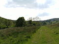 Looking into the valley from the path following the brook.
 -
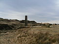 A view of the chimney, ruined buildings and spoil heaps of Musbury heights.


References
- ^ Musbury and Alden, 700 years of life and landscape; John Simpson; 2008 Helmshore Local History Society; ISBN 978-0-906881-19-4