
Nada, Kentucky
Nada | |
|---|---|
 Nada in 1968 | |
 Nada Location within the state of Kentucky  Nada Nada (the United States) | |
| Coordinates: 37°48′55″N 83°43′13″W / 37.81528°N 83.72028°W | |
| Country | United States |
| State | Kentucky |
| County | Powell |
| Elevation | 689 ft (210 m) |
| Population (2010) | |
| • Total | 52 |
| Time zone | UTC-5 (Eastern (EST)) |
| • Summer (DST) | UTC-5 (EST) |
| GNIS feature ID | 2420683[1] |
Nada is an unincorporated community in Powell County, Kentucky, United States.
History[edit]
Nada had its start in the year 1911 when the railroad was extended to that point; a sawmill was built there the same year.[2] The community lent its name to the nearby Nada Tunnel, originally a railroad tunnel completed in 1911.[3] The post office serving Nada was called Lombard.[2] This post office was established in 1901, and remained in operation until 1968.[4]
References[edit]
- ^ U.S. Geological Survey Geographic Names Information System: Nada, Kentucky
- ^ a b Rennick, Robert M. Kentucky Place Names. University Press of Kentucky. p. 209. ISBN 0-8131-2631-2.
- ^ Kappele, William; Kappele, Cora (April 1, 2000). Scenic Driving Kentucky. Globe Pequot Press. p. 45. ISBN 978-1-56044-733-7.
- ^ "Powell County". Jim Forte Postal History. Retrieved September 28, 2014.
Municipalities and communities of Powell County, Kentucky, United States | ||
|---|---|---|
| Cities | 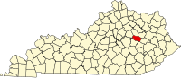 | |
| Unincorporated communities | ||
This Powell County, Kentucky state location article is a stub. You can help Wikipedia by expanding it. |