
Nanshi Subdistrict, Tianjin
Nanshi Subdistrict
南市街道 | |
|---|---|
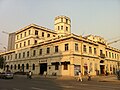
 Eastern end of Shipingjie Community, 2006 | |
.png) Location of Nanshi Subdistrict within Heping District | |
 Nanshi Subdistrict  Nanshi Subdistrict | |
| Coordinates: 39°07′39″N 117°10′53″E / 39.12750°N 117.18139°E | |
| Country | China |
| Municipality | Tianjin |
| District | Heping |
| Village-level Divisions | 9 communities |
| Area | |
| • Total | 1.27 km2 (0.49 sq mi) |
| Elevation | 7 m (23 ft) |
| Population (2010) | |
| • Total | 33,874 |
| • Density | 27,000/km2 (69,000/sq mi) |
| Time zone | UTC+8 (China Standard) |
| Postal code | 300021 |
| Area code | 022 |
Nanshi Subdistrict (Chinese: 南市街道; pinyin: Nánshì Jiēdào) is a subdistrict situated on the northwestern part of Heping District, Tianjin.[1] it borders Gulou Subdistrict to its north, Guangfudao Subdistrict to its east, Quanyechang Subdistrict to its south, and Xingnan Subdistrict to its west. It had 33,874 inhabitants under its administration as of 2010.[2]
The name Nanshi literally means "Southern City" or "Southern Market".
History[edit]
| Year | Status | Within |
|---|---|---|
| 1955 - 1956 | 8 Subdistricts | 1st District, Tianjin |
| 1956 - 1958 | 7 Subdistricts:
|
Heping District, Tianjin |
| 1958 - 1960 | Qinghe Subdistrict
Xing'an Road Subdistrict Dongxing Shichang Subdistrict | |
| 1960 - 1962 | Xing'an Road People's Commune | |
| 1962 - 1998 | Qinghe Subdistrict
Xing'an Road Subdistrict Dongxing Shichang Subdistrict | |
| 1998 - present | Nanshi Subdistrict |
Administrative divisions[edit]
In 2021, Nanshi Subdistrict was composed of 9 communities. They are listed as follows:[4]
| Subdivision Names | Name Transliterations |
|---|---|
| 庆有西里 | Qingyou Xili |
| 怀远里 | Huaiyuanli |
| 福厚西里 | Fuhou Xili |
| 福方里 | Fufangli |
| 裕德里 | Yudeli |
| 新文化花园 | Xinwenhua Huayuan |
| 新世界花园 | Xinshijie Huayuan |
| 食品街 | Shipingjie |
| 大都会 | Daduhui |
Gallery[edit]
-
 Both sides of Hai River east of the subdistrict, 2010
 -
 Yong'an Hospital, 2011
 -
 Lianzong Temple, 2011
 -
 Rongji Street, 2014


References[edit]
- ^ "天津市和平区人民政府-关于发布2021版天津市和平区行政区划图的公告_其他法定公开信息". www.tjhp.gov.cn. Retrieved 2022-11-01.
- ^ "中國: 天津市 (区、乡、镇、街道) - 人口统计,图表和地图". www.citypopulation.de. Retrieved 2022-11-01.
- ^ 中华人民共和国政区大典:天津市卷 (in Chinese). 中国社会出版社. 2020.
- ^ "2021年统计用区划代码和城乡划分代码". www.stats.gov.cn. Retrieved 2022-11-02.
This Tianjin location article is a stub. You can help Wikipedia by expanding it. |