Naunglon
Naunglon | |
|---|---|
Village | |
| Coordinates: 24°24′N 95°33′E / 24.400°N 95.550°E | |
| Country | |
| Region | Sagaing Region |
| District | Katha District |
| Township | Banmauk Township |
| Time zone | UTC+6.30 (MST) |
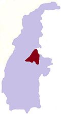
Naunglon is a village in Banmauk Township, Katha District, in the Sagaing Region of northern-central Burma.[1][2]
It is located 24 degree 24 minutes of North Latitude and 95 degree 33 minutes of East longitude and 38 mile from Bamauk and 35 mile from Pinlebu Town.
It is 140 households and 1 Buddhist monastery and 1 primary schools and 1 pre-school.So it is middle size village in that region.The village work mainly farm,digging of gold and forests ( timber, bamboo ). House are built with timber and bamboo.
The villagers are the Buddhist and speak Shan ( Shan Ni which derive from Tibet of China) and Kanan.The level of economic, education and health of the village is under the normal.
Transportation for goods and timber and other use carts and car.
References
- ^ Google Maps (Map). Google.
{{cite map}}:|access-date=requires|url=(help) - ^ Bing Maps (Map). Microsoft and Harris Corporation Earthstar Geographics LLC.
{{cite map}}:|access-date=requires|url=(help)


