Nes, Ørland
Appearance
Nes | |
|---|---|
Village | |
| Coordinates: 63°46′14″N 9°35′15″E / 63.7706°N 09.5876°E | |
| Country | Norway |
| Region | Central Norway |
| County | Trøndelag |
| District | Fosen |
| Municipality | Ørland |
| Elevation | 14 m (46 ft) |
| Time zone | UTC+01:00 (CET) |
| • Summer (DST) | UTC+02:00 (CEST) |
| Post Code | 7165 Oksvoll |
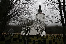
Nes is a village in Ørland municipality in Trøndelag county, Norway. The village is located on the western coast of the Fosen peninsula, just 8 kilometres (5.0 mi) east of the Tarva islands. Nes is located along the Norwegian County Road 115, about 12 kilometres (7.5 mi) west of the village of Botngård. Nes Church is located in the village. The village was once the administrative centre of the old municipality of Nes which existed from 1899 until its dissolution in 1964.[2]

References
- ^ "Nes, Bjugn (Trøndelag)". yr.no. Retrieved 2018-02-28.
- ^ Haugen, Morten, ed. (2009-02-14). "Nes – Sør-Trøndelag". Store norske leksikon (in Norwegian). Kunnskapsforlaget. Archived from the original on 2016-04-04. Retrieved 2018-02-28.


