Nezperce, Idaho
Nezperce, Idaho | |
|---|---|
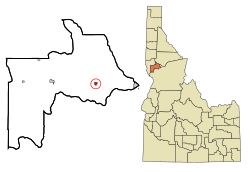
 Location in Lewis County and the state of Idaho | |
| Country | United States |
| State | Idaho |
| County | Lewis |
| Area | |
| • Total | 0.4 sq mi (1.1 km2) |
| • Land | 0.4 sq mi (1.1 km2) |
| • Water | 0.0 sq mi (0.0 km2) |
| Elevation | 3,215 ft (980 m) |
| Population (2000) | |
| • Total | 523 |
| • Density | 1,283.7/sq mi (495.6/km2) |
| Time zone | UTC-8 (Pacific (PST)) |
| • Summer (DST) | UTC-7 (PDT) |
| ZIP code | 83543 |
| Area code | 208 |
| FIPS code | 16-57250 |
| GNIS feature ID | 0396958 |
Nezperce is a city in and the county seat of Lewis County, Idaho, United States.Template:GR The population was 523 at the 2000 census. Nezperce is named for the local Nez Perce tribe of Native Americans Indians. ("Nezperce" derives from of corruption of French words nez percé, literally "pierced nose.")[citation needed]
Geography
Nezperce is located at 46°14′4″N 116°14′23″W / 46.23444°N 116.23972°WInvalid arguments have been passed to the {{#coordinates:}} function (46.234545, -116.239753).Template:GR Located at an altitude of 3215 feet (980 m),[1] the city lies on the Camas Prairie.[citation needed]
According to the United States Census Bureau, the city has a total area of 0.4 square miles (1.1 km²), all of it land.
Demographics
As of the censusTemplate:GR of 2000, there were 523 people, 197 households, and 150 families residing in the city. The population density was 1,283.7 people per square mile (492.5/km²). There were 225 housing units at an average density of 552.3/sq mi (211.9/km²). The racial makeup of the city was 91.20% White, 1.34% African American, 1.91% Native American, 1.34% Asian, 0.76% from other races, and 3.44% from two or more races. Hispanic or Latino of any race were 0.76% of the population.
| Census | Pop. | Note | %± |
|---|---|---|---|
| 1900 | 300 | — | |
| 1910 | 599 | 99.7% | |
| 1920 | 677 | 13.0% | |
| 1930 | 444 | −34.4% | |
| 1940 | 590 | 32.9% | |
| 1950 | 543 | −8.0% | |
| 1960 | 667 | 22.8% | |
| 1970 | 555 | −16.8% | |
| 1980 | 517 | −6.8% | |
| 1990 | 453 | −12.4% | |
| 2000 | 523 | 15.5% | |
| 2007 (est.) | 488 | ||
| source:[2][3] | |||
There were 197 households out of which 33.5% had children under the age of 18 living with them, 67.5% were married couples living together, and 23.4% were non-families. 22.3% of all households were made up of individuals and 12.7% had someone living alone who was 65 years of age or older. The average household size was 2.61 and the average family size was 3.05.
In the city the population was spread out with 29.8% under the age of 18, 4.2% from 18 to 24, 20.8% from 25 to 44, 24.7% from 45 to 64, and 20.5% who were 65 years of age or older. The median age was 42 years. For every 100 females there were 107.5 males. For every 100 females age 18 and over, there were 99.5 males.
The median income for a household in the city was $36,094, and the median income for a family was $40,000. Males had a median income of $30,625 versus $21,094 for females. The per capita income for the city was $15,450. About 5.7% of families and 7.4% of the population were below the poverty line, including 11.1% of those under age 18 and 3.3% of those age 65 or over.
Nezperce has a municipal airport, primarily used by cropdusters and light aircraft. The asphalt runway is 2,450' long, 30' feet wide, unlighted and has numerous obstructions. See airport/facility directory for more information.
References
- ^ U.S. Geological Survey Geographic Names Information System: Nezperce, Idaho
- ^ Moffatt, Riley. Population History of Western U.S. Cities & Towns, 1850-1990. Lanham: Scarecrow, 1996, 96.
- ^ "Subcounty population estimates: Idaho 2000-2007" (CSV). United States Census Bureau, Population Division. 2009-03-18. Retrieved 2009-05-06.

