
Nieuwendam
- Not to be confused with Nieuwendammerdijk en Buiksloterdijk or Tuindorp Nieuwendam.
Nieuwendam | |
|---|---|
 Coat of arms | |
| Coordinates: 52°23′30″N 4°56′26″E / 52.39167°N 4.94056°E | |
| Country | Netherlands |
| Province | |
| Municipality | Amsterdam |
| Borough | Noord |
Nieuwendam (literal translation: "new dam") is a neighbourhood of Amsterdam, Netherlands, best known for its marina Dutch: jachthaven). A former village in the province of North Holland, Nieuwendam was a separate municipality until 1921, when it merged with Amsterdam, on the same time as Ransdorp. The municipality also covered the village of Zunderdorp.[1] Nowadays, it is part of the Amsterdam-Noord borough.
-
 Marina of Nieuwendam
 -
 The Meerpadkerkje, a small mennonite church (Rijksmonument)
 -
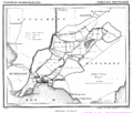 1867 map of the municipality of Nieuwendam
 -
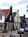 Former seamen's houses near the marina


References
- ^ Ad van der Meer and Onno Boonstra, Repertorium van Nederlandse gemeenten, KNAW, 2011.
External links
Wikimedia Commons has media related to Nieuwendam.
- Template:Kuyper Map of the former municipality, around 1868.