Paris Street Circuit
Appearance
 | |
| Location | Paris, France |
|---|---|
| Time zone | UTC+01:00 |
| Coordinates | 48°51′18″N 2°18′45″E / 48.85500°N 2.31250°E |
| Major events | Formula E 2016– |
| Website | http://www.paris-eprix.com/fr/ |
| Length | 1.93 km (1.20 miles) |
| Turns | 14 |
| Race lap record | 1.02.323 (Nick Heidfeld, Mahindra, 2016) |
The Paris Street Circuit is a street circuit located around Les Invalides in Paris, France. It is used for the Paris ePrix of the single-seater, electrically powered Formula E championship. Its was first used on 23 April 2016 for the 2016 Paris ePrix.[1]
Layout

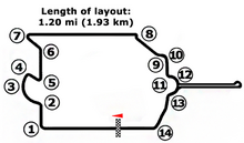
The track is 1.93 km in length and features 14 turns. It goes clock-wise around Les Invalides with the Musée de l'Armée and the tomb of Napoleon. The pit lane is located along the Esplanade des Invalides, north of Les Invalides.[1] It is characterised by a slippery surface, and a short section at turn 3 with new tarmac temporarily placed over the cobblestones.
References
- ^ a b "Track design for Paris ePrix revealed". fiaformulae.com. 2016-01-13.
