
Park Gate
| Park Gate | |
|---|---|
 Park Gate Location within Hampshire | |
| Area | 1.139 sq mi (2.95 km2) |
| Population | 7,811 |
| • Density | 6,858/sq mi (2,648/km2) |
| OS grid reference | SU5108 |
| District | |
| Shire county | |
| Region | |
| Country | England |
| Sovereign state | United Kingdom |
| Post town | Southampton |
| Postcode district | SO31 |
| Dialling code | 01489 |
| Police | Hampshire and Isle of Wight |
| Fire | Hampshire and Isle of Wight |
| Ambulance | South Central |
| UK Parliament | |
Park Gate is a locality in the Borough of Fareham[1] in Hampshire, England. It merges into Locks Heath to the south, Segensworth to the east and Sarisbury to the west. Within the area are two churches (Duncan Road Church and St Margaret Mary R.C[2]), a primary school[3] and a police station.[4] It is located to the south of Swanwick railway station.
Gallery
-
 St Margaret Mary R.C. Church, Park Gate
 -
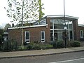
 Park Gate Police Station
 -
 Park Gate Primary School
 -
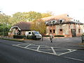
 Honeysuckle Close


Notes
- ^ local councillors Archived 2007-10-18 at the Wayback Machine
- ^ Church Web Site
- ^ School Web Site
- ^ Station details
External links
This Hampshire location article is a stub. You can help Wikipedia by expanding it. |