
Philippine, Netherlands
Philippine | |
|---|---|
Town | |
 Philipsplein square with bandstand | |
 Coat of arms | |
 | |
 The town centre (dark green) and the statistical district (light green) of Philippine in the municipality of Terneuzen. | |
| Coordinates: 51°16′58″N 3°45′31″E / 51.28278°N 3.75861°E | |
| Country | |
| Province | Zeeland |
| Municipality | Terneuzen |
| Population (31 December 2009) | |
| • Total | 2,127 |
| Time zone | UTC+1 (CET) |
| • Summer (DST) | UTC+2 (CEST) |
Philippine is a town in the Dutch province of Zeeland. It is a part of the municipality of Terneuzen, and lies about 23 km southeast of Vlissingen. It is located close to the border with Belgium, 5 km southwest of the city of Terneuzen. It received city rights in 1506.
Philippine has gained some renown for its mussel restaurants. On the village square there is a fountain in the shape of a mussel.
Philippine was a separate municipality until 1970, when it was merged with Sas van Gent.[1]
In 2001, the town of Philippine had 1,970 inhabitants. The built-up area of the town was 0.60 km², and contained 853 residences.[2] The statistical area "Philippines", which also can include the surrounding countryside, has a population of around 2,180.[3]
The landlord, Hieronymus Lauweryn, who founded the town in 1505, named it after Philip the Handsome.
Gallery
-
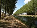 This canal runs adjacent to the northeast boundary of Philippine
 -
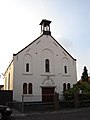 Reformed Church in Philippine
 -
 Catholic church of Our Lady at the St. Philips Square


References
- ^ Ad van der Meer and Onno Boonstra, Repertorium van Nederlandse gemeenten, KNAW, 2011.
- ^ Statistics Netherlands (CBS), Bevolkingskernen in Nederland 2001. (Statistics are for the continuous built-up area).
- ^ Statistics Netherlands (CBS), Statline: Kerncijfers wijken en buurten 2003-2005. As of 1 January 2005.
External links
- Template:Kuyper Map of the former municipality, around 1868.
- Historical map from the Special Collections of the Utrecht University Library, with explanation by the conservator of maps, Marco van Egmond