Preemption, Illinois
Appearance
Preemption, Illinois | |
|---|---|
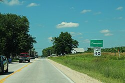
 Entering Preemption on U.S. Route 67 | |
| Coordinates: 41°18′46″N 90°35′04″W / 41.31278°N 90.58444°W | |
| Country | United States |
| State | Illinois |
| County | Mercer |
| Township | Preemption |
| Area | |
| • Total | 1.11 sq mi (2.88 km2) |
| • Land | 1.11 sq mi (2.88 km2) |
| • Water | 0.00 sq mi (0.00 km2) |
| Elevation | 810 ft (250 m) |
| Population | |
| • Total | 254 |
| • Density | 228.83/sq mi (88.31/km2) |
| Time zone | UTC-6 (Central (CST)) |
| • Summer (DST) | UTC-5 (CDT) |
| ZIP code | 61276 |
| Area code | 309 |
| GNIS feature ID | 416190[3] |
Preemption is an unincorporated community and census-designated place in Preemption Township, Mercer County, Illinois, United States.[4] As of the 2020 census, it had a population of 254.[2] Preemption is 4 miles (6 km) west of Sherrard and has a post office with ZIP code 61276.[5]
Roy James Carver (1909-1981), American philanthropist and businessman, was born in Preemption.[6]
Demographics
[edit]| Census | Pop. | Note | %± |
|---|---|---|---|
| 2020 | 254 | — | |
| U.S. Decennial Census[7] | |||
References
[edit]- ^ "2022 U.S. Gazetteer Files: Illinois". United States Census Bureau. Retrieved March 17, 2023.
- ^ a b "P1. Race – Preemption CDP, Illinois: 2020 DEC Redistricting Data (PL 94-171)". U.S. Census Bureau. Retrieved March 17, 2023.
- ^ "US Board on Geographic Names". United States Geological Survey. October 25, 2007. Retrieved January 31, 2008.
- ^ Mercer County General Highway Map (PDF) (Map). Illinois Department of Transportation. 1988. Archived from the original (PDF) on March 20, 2012. Retrieved May 26, 2011.
- ^ ZIP Code Lookup
- ^ 'Roy J. Carver 71; Iowa Businessman,' The New York Times, June 18, 1971, section B, pg. 14
- ^ "Census of Population and Housing". Census.gov. Retrieved June 4, 2016.


