
Prokop Valley
Prokop Valley (Czech: Prokopské údolí) is a recreational area in south-western Prague, located in the districts of Barrandov, Holyně, Řeporyje, Stodůlky and Hlubočepy. It encompasses two streams, Dalejský potok and Prokopský potok, the latter of which is surrounded by a valley, despite the fact that it is much shorter. The area includes a natural reserve which encompasses a far wider area than the valley.
In the valley there was once a limy open-cast mine, therefore a lake and a cave cropped up. The first attempts to gain lime were in the year 1860.[1] The territory is equipped with benches.
Illustrations
-
 Prokop valley nature reserve
 -
 The valley
 -
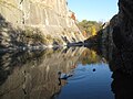 A lake that tourists like
 -
 Viaduct on the Prague Semmering railway line


.jpg)

- Panorama

A view over all the surroundings, through the Vltava river to Vyšehrad, which be seen far away to the left
References
External links
- 58 - Přírodní rezervace Prokopské údolíTemplate:Cz icon information about the natural reserve.
50°02′N 14°22′E / 50.033°N 14.367°E
This Prague location article is a stub. You can help Wikipedia by expanding it. |