Puszta
This article needs additional citations for verification. (January 2022) |
It has been suggested that this article be merged into Pannonian Steppe. (Discuss) Proposed since January 2022. |
| Puszta | |
|---|---|
 | |
| Ecology | |
| Realm | Eurasian Steppe |
| Biome | temperate grassland |
| Geography | |
| Country | Hungary |
| Coordinates | 47°30′N 21°06′E / 47.5°N 21.1°E |

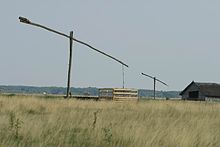
The Hungarian Puszta (Hungarian pronunciation: [ˈpustɒ]) is a temperate grassland biome of the Alföld or Great Hungarian Plain.[1]: 66 It is an exclave of the Eurasian Steppe, and lies mainly around the River Tisza in the eastern part of Hungary, as well as in the western part of the country and in the Burgenland of Austria.
It covers a total area of about 50,000 km2 (19,000 sq mi).[2]: 1781 The characteristic landscape is composed of treeless plains, saline steppes and salt lakes, and includes scattered sand dunes, low, wet forests and freshwater marshes along the floodplains of the ancient rivers.[2]: 1781 It is strongly associated with traditional Hungarian breeds of domestic animal including the Hungarian Grey breed of cattle, the Mangalitsa breed of woolly pig, the Nonius breed of horse and the Racka breed of horned sheep,[3]: 78 and also with the traditions of the csikós mounted herdsmen.[3]: 77
Name
The adjective puszta has meanings including 'abandoned', 'bare', 'bleak', 'deserted' and 'uninhabited'.[4]: 565
History
From the late Pleistocene era the landscape of the Alföld or Great Hungarian Plain consisted in large part of arid alkaline grasslands devoid of trees – the puszta.[5] The extent of the puszta over much of the Alföld was drastically reduced by the extensive drainage and irrigation works carried out during the nineteenth century, and it survives principally in the Hortobágy National Park, established in 1972 in eastern Hungary and centred on the village of Hortobágy in Hajdú-Bihar County.[5][6]
Climate
The climate is continental. Landscape is widely cultivated, the original Puszta landscape now being found only in a few places, for example in Hortobágy National Park.
Agriculture
Most of Hungary's vegetable and grain crops are grown on the Great Plain.[7] The region has a sandy soil and is sunny;[7] the city of Szeged is often called City of Sunshine (Napfény városa).[8][better source needed] In addition to cattle, sheep, and pigs, the region also produces poultry and foie gras.[7]
Fauna
Three hundred species of birds are found here.[2]: 1781
References
- ^ Ward Chesworth (2008). Encyclopedia of Soil Science, Dordrecht; Berlion; Heidelberg; New York: Springer. ISBN 9781402039959.
- ^ a b c Peter Haggett, Graham Bateman (1993). Encyclopedia of World Geography: Eastern Europe. New York: Barnes & Noble; Abingdon, Oxfordshire: Andromeda Oxford. ISBN 9781566192910
- ^ a b Cesare Della Pietà, Mariella Bussolati, Hans Silvester (May 1987). La puszta di Hortobágy (in Italian). Silva. I (2): 70–85.
- ^ István Kiséry (editor) (2006). Magyar angol kisszótár = Hungarian-English Dictionary. Budapest: Akadémiai Kiadó. ISBN 9789630583589.
- ^ a b Hortobágy National Park - the Puszta. UNESCO World Heritage Centre. Accessed January 2022.
- ^ [s.n.] (2021). Puszta. Columbia Electronic Encyclopedia, sixth edition. New York: Columbia University Press. Accessed January 2022.
- ^ a b c Gergely, Anikó (2008). Culinaria Hungary. Ruprecht Stempell, Christoph Büschel, Mo Croasdale. Potsdam, Germany: H.F. Ullmann. pp. 12–16. ISBN 978-3-8331-4996-2. OCLC 566879902.
- ^ "A napfény városa". www.origo.hu/. 5 August 2006.
{{cite web}}: CS1 maint: url-status (link)
