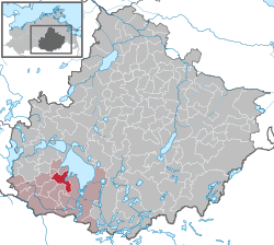
Röbel
Appearance
Röbel | |
|---|---|
| Country | Germany |
| State | Mecklenburg-Vorpommern |
| District | Mecklenburgische Seenplatte |
| Municipal assoc. | Röbel-Müritz |
| Government | |
| • Mayor | Heiner Müller (SPD) |
| Area | |
| • Total | 30.17 km2 (11.65 sq mi) |
| Elevation | 65 m (213 ft) |
| Population (2022-12-31)[1] | |
| • Total | 5,075 |
| • Density | 170/km2 (440/sq mi) |
| Time zone | UTC+01:00 (CET) |
| • Summer (DST) | UTC+02:00 (CEST) |
| Postal codes | 17207 |
| Dialling codes | 039931 |
| Vehicle registration | MÜR |
| Website | http://www.amt-roebel-mueritz.de/ |

Röbel is a municipality in the Mecklenburgische Seenplatte district, in Mecklenburg-Western Pomerania, Germany. It is situated on the western shore of Lake Müritz, 25 km north of Wittstock, and 27 km southwest of Waren. It is part of the Amt Röbel-Müritz.
Sights

The museum Engelscher Hof and the half-timbered former synagogue provide a permanent exhibition on Mecklenburg's Jewish history, commemorating - among other things - the life and work of Israel Jacobson, formerly consistorial president in the Kingdom of Westphalia and feudal landlord in Jördenstorf.


References
- ^ "Bevölkerungsstand der Kreise, Ämter und Gemeinden 2022" (XLS) (in German). Statistisches Amt Mecklenburg-Vorpommern. 2023.
External links
![]() Media related to Röbel/Müritz at Wikimedia Commons
Media related to Röbel/Müritz at Wikimedia Commons


