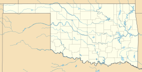
Raymond Gary State Park
| Raymond Gary State Park | |
|---|---|
| Location | Choctaw County, Oklahoma, United States |
| Nearest city | Fort Towson, Oklahoma |
| Coordinates | 33°59′38″N 95°15′58″W / 33.9939951°N 95.2660658°W[1] |
| Governing body | Oklahoma Tourism and Recreation Department |
| www | |
Raymond Gary State Park is an Oklahoma state park located in southeast Oklahoma. The park borders Raymond Gary Lake, which covers 263 acres (106 ha) and offers opportunities for fishing, boating, swimming, and camping.[2][3][4]
Park facilities include a fishing dock (handicap accessible), two unlighted boat ramps, picnic sites, recreational vehicle sites, six cabins, a swimming area and children's playground.[5]
References
- ^ "Raymond Gary State Park". Geographic Names Information System. United States Geological Survey, United States Department of the Interior. Retrieved January 6, 2013.
- ^ "Raymond Gary State Park". Oklahoma Tourism and Recreation Department. Archived from the original on February 23, 2013. Retrieved January 6, 2013.
- ^ "Lake Raymond Gary". Oklahoma Department of Wildlife Conservation. Archived from the original on February 23, 2013. Retrieved January 6, 2013.
- ^ "Lake Raymond Gary". Oklahoma Tourism and Recreation Department. Archived from the original on February 23, 2013. Retrieved January 6, 2013.
- ^ "Raymond Gary State Park." Retrieved August 8, 2014.

