
Red Apple, Alabama
Red Apple, Alabama | |
|---|---|
 Red Apple, Alabama | |
| Coordinates: 34°10′57″N 86°12′02″W / 34.18250°N 86.20056°W | |
| Country | United States |
| State | Alabama |
| County | Marshall |
| Elevation | 1,014 ft (309 m) |
| Time zone | UTC-6 (Central (CST)) |
| • Summer (DST) | UTC-5 (CDT) |
| Area code(s) | 256 & 938 |
| GNIS feature ID | 139469[1] |
Red Apple is a ghost town in Marshall County, in the U.S. state of Alabama.
History
A post office called Red Apple was established in 1870, and remained in operation until it was discontinued in 1903.[2] The community was named from an apple orchard near the town site.[3]
References
- ^ "Red Apple". Geographic Names Information System. United States Geological Survey, United States Department of the Interior.
- ^ "Marshall County". Jim Forte Postal History. Retrieved 20 May 2015.
- ^ Smith, Katie (Jun 17, 1984). "Names often lend special air to places". Gadsden Times. pp. B1. Retrieved 20 May 2015.
Municipalities and communities of Marshall County, Alabama, United States | ||
|---|---|---|
| Cities | 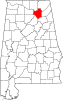 | |
| Towns | ||
| CDPs | ||
| Unincorporated communities | ||
| Ghost town | ||
| Footnotes | ‡This populated place also has portions in an adjacent county or counties | |
This Alabama state location article is a stub. You can help Wikipedia by expanding it. |