
Robjohn, Alabama
Robjohn, Alabama | |
|---|---|
 Robjohn, Alabama  Robjohn, Alabama | |
| Coordinates: 32°12′51″N 88°07′38″W / 32.21417°N 88.12722°W | |
| Country | United States |
| State | Alabama |
| County | Choctaw |
| Elevation | 98 ft (30 m) |
| Time zone | UTC-6 (Central (CST)) |
| • Summer (DST) | UTC-5 (CDT) |
| Area code | 205 |
| GNIS feature ID | 125740[1] |
Robjohn is an unincorporated community in Choctaw County, Alabama, United States. Robjohn is located on Alabama State Route 156, 4.5 miles (7.2 km) west of Pennington. Robjohn had a post office, which opened on July 14, 1888, and closed on January 31, 1955.[2]
References
Municipalities and communities of Choctaw County, Alabama, United States | ||
|---|---|---|
| Towns | 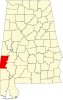 | |
| CDP | ||
| Unincorporated communities | ||
| Footnotes | ‡This populated place also has portions in an adjacent county or counties | |
This Alabama state location article is a stub. You can help Wikipedia by expanding it. |