
Rock Islands
Nickname: Chelbacheb | |
|---|---|
 | |
| Geography | |
| Coordinates | 7°14′N 134°18′E / 7.233°N 134.300°E |
| Administration | |
Palau | |
| Demographics | |
| Population | 6 |
The Rock Islands of Palau, also called Chelbacheb, are a small collection of limestone or coral uprises, ancient relics of coral reefs that violently surfaced to form Islands in Palau's Southern Lagoon, between Koror and Peleliu, and are now an incorporated part of Koror State. There are between 250 and 300 islands in the group according to different sources, with an aggregate area of 47 square kilometres (18 sq mi) and a height up to 207 metres (679 ft). They are a World Heritage Site since 2012.
The islands are sparesly populated and are famous for their beaches, blue lagoons and the peculiar umbrella-like shapes of many of the islands themselves. The Rock Islands and the surrounding reefs make up Palau's popular tourist sites such as Blue Corner, Blue hole, German Channel, Ngermeaus Island and the famed Jellyfish Lake, one of the many Marine lakes in the Rock Islands that provides home and safety for several kinds of stingless jellyfish found only in Palau. It is the most popular dive destination in Palau, and offers some of the best and most diverse dive sites on the planet. From wall diving to high current drift dives, from Manta Rays to sharkfeeds an from shallow and colorful lagoons to brilliantly decorated caves and overhangs. The islands are the location of Dolphin Bay - where there is a staff of vets and trainers that educate about the life of dolphins.
Many of the islands' display a mushroom-like shape with a smaller base at the intertidal notch than what lies above it. The indentation comes from erosion and from the dense community of sponges, bivalves, chitons, snails, urchins and others that graze mostly on algae.[1]
The largest islands in the group are:
- Ngeruktabel
- Ulong
- Eil Malk (Mecherchar)
Other notable islands include:
- Ngeteklou (Gologugeul)
- Bukrrairong (Kamori)
- Tlutkaraguis (Adorius)
- Ongael
- Ngebedangel (Ngobasangel)
- Bablomekang (Abappaomogan)
- Ngerukeuid (Orukuizu)
Demographics
The only inhabited place on the islands is called Dolphin Bay. it is the location of Palau's national aquatics park, and the HQ of Palau's Park rangers.
Gallery
-
 Divers descending into the main cavern of Blue Hole.
 -
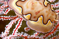
 A Small giant clam (Tridacna maxima).
 -
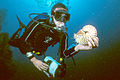
 Divers descending next to the mast of the Japanese tanker Iro.
 -
 An Anenomefish on the wreck of the Japanese tanker Iro.
 -
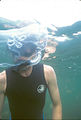 Diver and large Moon jellyfish, Jellyfish Lake.
 -
 Diver and jellyfish, Jellyfish Lake.
 -
 Jellyfish in Jellyfish Lake.
 -
 Diver and Nautilus, German Channel.
 -
 Nudibranch on sea fan.
 -
 Soft corals growing on vertical wall.
 -
 Closeup of soft coral.
 -
 Starfish on soft coral.
 -
 Diver and large table coral.
 -
 Divers on a vertical wall, Peleliu Island.
 -
 One of the many Rock Islands.
 -
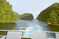 Channel between the Rock Islands.


Notes
- ^ Murphy, Richard C. (2002). Coral Reefs: Cities Under The Seas. The Darwin Press, Inc. pp. 60–61. ISBN 0-87850-138-X.