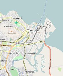
Ross Island (Townsville, Queensland)
Appearance


Ross Island is an island in City of Townsville, Queensland, Australia.[1]
Geography
Ross Island is the land that lies between Ross Creek and Ross River and the Coral Sea. Ross Creek is itself a small estuarine portion of the Ross River which creates a bay inlet at the Coral Sea. Ross Island is divided into two suburbs of Townsville: South Townsville on the north of the island and Railway Estate on the south of the island.[2]
History
Ross Island is named after William Alfred Ross, European pioneer of the Townsville area and its first publican.[1]
References
- ^ a b "Ross Island – City of Townsville (entry 29103)". Queensland Place Names. Queensland Government. Retrieved 25 February 2016.
- ^ "Queensland Globe". State of Queensland. Retrieved 25 February 2016.
19°16′15″S 146°49′19″E / 19.27083°S 146.82194°E
Wikimedia Commons has media related to Ross Island (Townsville, Queensland).
