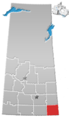
Rural Municipality of Storthoaks No. 31
Appearance
Storthoaks No. 31 | |
|---|---|
| Coordinates: 49°25′19″N 101°32′7″W / 49.42194°N 101.53528°W | |
| Country | Canada |
| Province | Saskatchewan |
| Area | |
| • Total | 582.57 km2 (224.93 sq mi) |
| Population (2001) | |
| • Total | 383 |
| • Density | 0.66/km2 (1.7/sq mi) |
The Rural Municipality of Storthoaks No. 31, Saskatchewan was originally called Storkoaks and is now named Storthoaks as of March 15, 1912. The original founding date of Storthoaks was December 11, 1911 [1]
Population
As of the census in 2001, there were 383 people living in the municipality.
Statistics
According to the Canada 2001 Census:
- Population: 383
- % Change (1996-2001): -17.1
- Dwellings: 141
- Area (km²): 582.57
- Density (persons per km²): 0.7
Urban communities
Saskatchewan railways and railway stations
(historic or current)
- Estevan Section C.P.R. -- serves Lauder, Bernice, Bede, Broomhill, Tilston, Fertile, Storthoaks, Nottingham, Alida
Saskatchewan highways and roads
- For more information see also List of Saskatchewan provincial highways
- For more information see also List of Saskatchewan provincial roads
- Highway 361—serves Storthoaks, Saskatchewan
- Highway 8—North south Highway to the west of Storthoaks, Saskatchewan
- Highway 600—North south section of the Highway to the east of Storthoaks, Saskatchewan
- Highway 361—East West Highway to the east of Storthoaks, Saskatchewan
See also
Footnotes
External links
- Cornerstone REDA Welcome to the R.M. of Storthoaks No. 31
- Weyburn Gen Web
- Sarm
- Saskatchewan Rural Development
- RM Government from Municipal Directory System
- 2001 Census - Statistics Canada's page on the 2001 Census.
- Municipal Relations Division - RM Boundary Changes
- Saskatchewan Genealogy Society RM by Number
- MRD - Municipal Status Information - Rural Municipality
- SARM In Memoriam
- Map of Storthoaks No. 31 at Statcan


