
Russell City, Pennsylvania
Russell City, Pennsylvania | |
|---|---|
Unincorporated community | |
 Russell City | |
| Coordinates: 41°34′17″N 78°54′31″W / 41.57139°N 78.90861°W | |
| Country | United States |
| State | Pennsylvania |
| County | Elk |
| Elevation | 1,909 ft (582 m) |
| Time zone | UTC-5 (Eastern (EST)) |
| • Summer (DST) | UTC-4 (EDT) |
| ZIP code | 16728 |
| Area code | 814 |
| GNIS feature ID | 1209944[1] |
Russell City (also known as De Young or Deyoung) is an unincorporated community in Elk County, Pennsylvania, United States.[1] The community is located along Pennsylvania Route 66 and Pennsylvania Route 948 14 miles (23 km) northwest of Ridgway. Russell City had a post office until April 23, 2005; it still has its own ZIP code, 16728.[2][3]
References
- ^ a b "Russell City". Geographic Names Information System. United States Geological Survey, United States Department of the Interior.
- ^ United States Postal Service. "USPS - Look Up a ZIP Code". Retrieved July 23, 2017.
- ^ "Postmaster Finder - Post Offices by ZIP Code". United States Postal Service. Retrieved July 23, 2017.
Municipalities and communities of Elk County, Pennsylvania, United States | ||
|---|---|---|
| City | 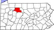 | |
| Boroughs | ||
| Townships | ||
| CDPs | ||
| Unincorporated communities | ||
This Elk County, Pennsylvania state location article is a stub. You can help Wikipedia by expanding it. |