
Saint-Julia
This article includes a list of references, related reading, or external links, but its sources remain unclear because it lacks inline citations. (September 2015) |
Saint-Julia | |
|---|---|
.jpg) | |
.svg) Coat of arms | |
Location of Saint-Julia  | |
| Country | France |
| Region | Occitania |
| Department | Haute-Garonne |
| Arrondissement | Toulouse |
| Canton | Revel |
| Intercommunality | Lauragais-Revel-Sorezois |
| Government | |
| • Mayor (2008–2014) | Raymond Martinazzo |
| Area 1 | 11.46 km2 (4.42 sq mi) |
| Population (2008) | 376 |
| • Density | 33/km2 (85/sq mi) |
| Time zone | UTC+01:00 (CET) |
| • Summer (DST) | UTC+02:00 (CEST) |
| INSEE/Postal code | 31491 /31540 |
| Elevation | 200–301 m (656–988 ft) (avg. 293 m or 961 ft) |
| 1 French Land Register data, which excludes lakes, ponds, glaciers > 1 km2 (0.386 sq mi or 247 acres) and river estuaries. | |
Saint-Julia is a commune in the Haute-Garonne department in southwestern France.
Population
| Year | Pop. | ±% |
|---|---|---|
| 1962 | 300 | — |
| 1968 | 382 | +27.3% |
| 1975 | 370 | −3.1% |
| 1982 | 314 | −15.1% |
| 1990 | 305 | −2.9% |
| 1999 | 333 | +9.2% |
| 2008 | 376 | +12.9% |
-
 Church and Town hall
 -
 Interior of church
 -
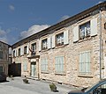 Town hall
.jpg)


See also
References
Wikimedia Commons has media related to Saint-Julia.
This Haute-Garonne geographical article is a stub. You can help Wikipedia by expanding it. |