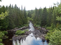
Saint Francis River (Canada–United States)
| Saint Francis River | |
|---|---|
 | |
 | |
| Physical characteristics | |
| Mouth | Saint John River |
• elevation | 530 feet (160 m) |
The St. Francis River (French: Rivière Saint-François) is a river roughly 75 miles (120 km) long, which forms part of the Canada–United States border. The river rises (47°44′07″N 69°17′15″W / 47.7352°N 69.2874°W) in a lake of the same name located 12 miles (20 km) east of the Rivière du Loup in Quebec. The portion that forms the boundary starts at the bottom of Lake Pohenegamook at the very northernmost point of New England between Estcourt Station, Maine, and Estcourt, Quebec. The river flows generally south-east to its mouth on the Saint John River at St. Francis, Maine/Saint-François-de-Madawaska, New Brunswick.[1]
USS Bancroft (DD-256) became a Canadian ship as part of the Destroyers for Bases Agreement and was renamed after the St. Francis River to follow the Canadian tradition of naming destroyers after Canadian rivers while recognizing the shared national history of the ship.[2]
See also
References
- Bailey, J.W. (1894). The St. John River in Maine, Quebec, and New Brunswick. Cambridge: Riverside Press. Retrieved 2008-09-18.
- Milner, Marc (1985). North Atlantic Run. Naval Institute Press. ISBN 0-87021-450-0.
- "Saint Francis River". Geographic Names Information System. United States Geological Survey, United States Department of the Interior. 30 September 1980. Retrieved 2009-10-18.
47°10′49″N 68°54′14″W / 47.1802°N 68.9040°W
- Rivers of Aroostook County, Maine
- Rivers of New Brunswick
- Rivers of Quebec
- Tributaries of the Saint John River (Bay of Fundy)
- Geography of Madawaska County, New Brunswick
- Borders of Maine
- Geography of Bas-Saint-Laurent
- International rivers of North America
- Rivers of Maine
- Landforms of Aroostook County, Maine
- Quebec geography stubs
