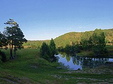
Salair Ridge

Salair Ridge (pronounced sah-lah-EER; Russian: Салаирский кряж) is an eroded plateau-type highland in the Southwestern Siberia, Russia, particularly in Altai Krai, Kemerovo and Novosibirsk Oblast. It is a natural continuation of Altai Mountains and separates the Kuznetsk Depression from the Ob River Plain to the southwest. See Geography of South-Central Siberia. Its main ridge is nearly parallel to that of Kuznetsk Alatau. The ridge is some 300 kilometres in length and 15-40 kilometres wide.
The mountains are rich in complex ores. The highest peak is Kivda (Russian: Кивда), at 621 meters.
Major rivers include the Berd' (Russian: Бердь, see the city of Berdsk), Suenga River (Russian: Суенга) and Chumysh River.
External links
54°05′23″N 85°49′40″E / 54.0897°N 85.8278°E
