
San Felice sul Panaro
San Felice sul Panaro | |
|---|---|
| Comune di San Felice sul Panaro | |
Location of San Felice sul Panaro  | |
| Country | Italy |
| Region | Emilia-Romagna |
| Province | Province of Modena (MO) |
| Frazioni | Dogaro, Pavignane, Rivara, San Biagio in Padule |
| Area | |
| • Total | 51.5 km2 (19.9 sq mi) |
| Population (Dec. 2004)[2] | |
| • Total | 10,453 |
| • Density | 200/km2 (530/sq mi) |
| Demonym | Sanfeliciani |
| Time zone | UTC+1 (CET) |
| • Summer (DST) | UTC+2 (CEST) |
| Postal code | 41038 |
| Dialing code | 0535 |
| Website | Official website |
San Felice sul Panaro is a comune (municipality) in the Province of Modena in the Italian region Emilia-Romagna, located about 40 kilometres (25 mi) northwest of Bologna and about 25 kilometres (16 mi) northeast of Modena.
Characteristics
San Felice sul Panaro since Roman times has been an important center of the central Po valley in northern Italy. The main activity was farming until the development of agriculture related industries during the 20th century.
As of 31 December 2004, it had a population of 10,453 and an area of 51.5 square kilometres (19.9 sq mi).[3]
The municipality of San Felice sul Panaro contains the frazioni (subdivisions, mainly villages and hamlets) Dogaro, Pavignane, Rivara, and San Biagio in Padule.
San Felice sul Panaro borders the following municipalities: Camposanto, Finale Emilia, Medolla, Mirandola.
In the last ten years San Felice has achieved importance even because of the Magic Carnival, one of the main in northern Italy, done in march with a "photo festival".[4]
2012 earthquakes
The region was struck by a two earthquakes in May 2012. The first earthquake, with a magnitude of 6.0, occurred on May 20, 2012. Although no residents of San Felice sul Panaro were reported to have died, the town's Rocca Estense castle was severely damaged by the quake.[5]
A 5.8 magnitude earthquake struck the region On May 29, 2012, killing at least 17 people and collapsing churches and factories. About 200 people were injured 14,000 people were left homeless.[6] At least three of the deaths occurred in San Felice sul Panaro when the roof of a machine shop collapsed on workers.[7]
Demographic evolution

Gallery
-
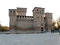 "Rocca Estense" (Castle)
 -
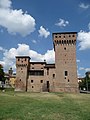 South view of the "Rocca"
 -
 "Teatro Comunale"
(Theater) -
 "Casa Comunale" (City Hall)
 -
 Piazza della "Banca Popolare" di San Felice (Main Square)
 -
 Earthquake damage to Rocca Estense castle, San Felice sul Panaro, Italy, following the 2012 earthquake.


References
- ^ "Superficie di Comuni Province e Regioni italiane al 9 ottobre 2011". Italian National Institute of Statistics. Retrieved 16 March 2019.
- ^ "Popolazione Residente al 1° Gennaio 2018". Italian National Institute of Statistics. Retrieved 16 March 2019.
- ^ All demographics and other statistics: Italian statistical institute Istat.
- ^ Magico Carnevale
- ^ "Italy quake victims wake in cars, tents, schools". San Diego Union-Tribune. Associated Press. May 21, 2012. Retrieved May 30, 2012.
- ^ Barry, Colleen (May 30, 2012). "17 dead and 200 injured in latest killer quake in northern Italy". Dailystar.
- ^ Arsie, Alberto (May 30, 2012). "Workers among 16 dead in latest big Italian quake". Associated Press. Retrieved May 30, 2012.
External links
- Images of San Felice sul Panaro, with detailed informations. (In Italian)
- Movie on the "Rocca Estense", the castle of San Felice sul Panaro
| International | |
|---|---|
| Geographic | |