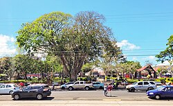
San Ramón, Costa Rica
San Ramón | |
|---|---|
 Alberto Manuel Brenes Park, Downtown San Ramón | |
 San Ramón district | |
| Coordinates: 10°5′15″N 84°28′12″W / 10.08750°N 84.47000°W | |
| Country | |
| Province | Alajuela |
| Canton | San Ramón |
| Founded | 1854 |
| Government | |
| • Mayor | Nixon Ureña |
| • Substitute syndic | Milagro Zamora Mora |
| Area | |
| • Total | 1.28 km2 (0.49 sq mi) |
| Elevation | 1,057 m (3,468 ft) |
| Population (2011) | |
| • Total | 8,717 |
| • Density | 6,800/km2 (18,000/sq mi) |
| Time zone | UTC−06:00 |
| Postal code | 20201 |
| Website | http://www.sanramon.go.cr/ |
San Ramón is a district in the canton of San Ramón in Alajuela Province in Costa Rica. The central municipality (distrito) of San Ramón covers an area of 1.29 km2 (0.50 sq mi)[1] and has a population of 10,710.[2] Together with adjoining distritos, it forms what is colloquially known as Ciudad de San Ramón (San Ramón City). However, cities are no longer a valid administrative division in Costa Rica, by municipal codex law 7794 of April 30, 1998.[3][4][5]
The district lies at an elevation of 1,057 m (3,468 ft) above sea level[1] in the Cordillera de Tilarán.
Location
[edit]
San Ramon is located 55 kilometers northeast of Puntarenas on the Gulf of Nicoya, 44 kilometers northwest of the provincial capital city of Alajuela and 58 kilometers from the national capital city of San Jose.
The plaza is located 47 km WNW of Costa Rica's parliament building in the center of the capital city of San José and 31 km from Juan Santamaría International Airport in Alajuela. Its location in the central valley (Meseta Central) is c.33 km east of the Pacific coast near Puntarenas, and c.140 km west of the Caribbean at a point north of Limón. One route runs out of the north of town directly to the popular Costa Rican destination of Volcan Arenal, and the Pan-American Highway runs just south of the city's southern edge granting easy access to all other north-south points in the country, as well as linking San Ramón to the Americas.
Geography
[edit]San Ramón has an area of 1.28 km2[6] and an elevation of 1057 metres.[4]
Climate
[edit]
Despite the tropical latitude of San Ramón, temperatures tend to be warm rather than hot year-round: 13 to 27 °C or 55.4 to 80.6 °F.[7] This is largely due to the city's altitude of 1,057 m (3,468 ft) above sea level. June through October is considered the rainy or "green" season with November to May considered the "dry season." Diurnal periods are very predictable due to Costa Rica's latitude: The sun rises in San Ramon by about 05:45 and sets at 18:30 with very little variation throughout the year. This regular cycle is further evident in the precipitation patterns, particularly during the rainy season. As the morning sun rises, air which is already moist due to a certain amount of orographic lift being added by the Pacific Ocean, is further loaded by evapotranspiration wherein water drawn from the ground by plants and trees is transpired into the atmosphere. This leads to a relatively consistent pattern of mostly dry mornings followed by rains in the afternoon, usually beginning around 14:00. Rains can last for a short period, or for several hours, and there is a seemingly equal chance that there will either be a downpour or a drizzle. Evenings can be cooler than one might expect due to altitude, and cooler still in the evenings following rain. At the highest elevations, temperatures down to 9 °C or 48.2 °F have been recorded.[7]
Demographics
[edit]| Census | Pop. | ±% p.a. |
|---|---|---|
| 1864 | 1,618 | — |
| 1883 | 1,953 | +1.00% |
| 1892 | 1,989 | +0.20% |
| 1927 | 2,722 | +0.90% |
| 1950 | 4,292 | +2.00% |
| 1963 | 6,973 | +3.80% |
| 1973 | 9,245 | +2.86% |
| 1984 | 9,624 | +0.37% |
| 2000 | 9,659 | +0.02% |
| 2011 | 8,717 | −0.93% |
| 2022 | 7,725 | −1.09% |
| Source: Instituto Nacional de Estadística y Censos[8] Centro Centroamericano de Población[9] | ||
For the 2011 census, San Ramón had a population of 8,717 inhabitants.[10]
See also
[edit]References
[edit]- ^ a b Instituto Geográfico Nacional (IGN), 2001
- ^ Estimates of Instituto Nacional de Estadística y Censos (INEC), May 2003
- ^ "División Territorial Administrativa de la República".
- ^ a b "Declara oficial para efectos administrativos, la aprobación de la División Territorial Administrativa de la República N°41548-MGP". Sistema Costarricense de Información Jurídica (in Spanish). 19 March 2019. Retrieved 26 September 2020.
- ^ División Territorial Administrativa de la República de Costa Rica (PDF) (in Spanish). Editorial Digital de la Imprenta Nacional. 8 March 2017. ISBN 978-9977-58-477-5.
- ^ "Área en kilómetros cuadrados, según provincia, cantón y distrito administrativo". Instituto Nacional de Estadística y Censos (in Spanish). Retrieved 26 September 2020.
- ^ a b "Instituto Meteorológico Nacional". Retrieved 2016-11-24.
- ^ "Instituto Nacional de Estadística y Censos" (in Spanish).
- ^ Centro Centroamericano de Población de la Universidad de Costa Rica. "Sistema de Consulta a Bases de Datos Estadísticas" (in Spanish).
- ^ "Censo. 2011. Población total por zona y sexo, según provincia, cantón y distrito". Instituto Nacional de Estadística y Censos (in Spanish). Retrieved 26 September 2020.
External links
[edit]- Timeline history of San Ramon, Historical citations
- Municipality of San Ramón, official website
- Museum of San Ramón, University of Costa Rica
- Palmares and San Ramon, Palmares y San Ramon

