
Sande, Lower Saxony
Sande | |
|---|---|
 Water castle | |
 Coat of arms | |
Location of Sande within Friesland district 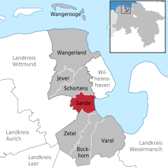 | |
 Sande  Sande | |
| Coordinates: 53°29′N 8°0′E / 53.483°N 8.000°E | |
| Country | Germany |
| State | Lower Saxony |
| District | Friesland |
| Subdivisions | 7 districts |
| Government | |
| • Mayor | Josef Wesselmann |
| Area | |
| • Total | 45 km2 (17 sq mi) |
| Elevation | 0 m (0 ft) |
| Population (2022-12-31)[1] | |
| • Total | 8,622 |
| • Density | 190/km2 (500/sq mi) |
| Time zone | UTC+01:00 (CET) |
| • Summer (DST) | UTC+02:00 (CEST) |
| Postal codes | 26452 |
| Dialling codes | 0 44 22 |
| Vehicle registration | FRI |
| Website | www.sande.de |
Sande is a municipality in the district of Friesland, Lower Saxony, Germany. It is situated near the Jade Bight, approximately 7 km west of Wilhelmshaven, and 12 km southeast of Jever.
Sande is on the railway which links Oldenburg to Wilhelmshaven and Esens. A bypass is planned so that rail traffic for the JadeWeserPort will not pass through the centre of Sande.[2]
-
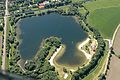 Sander Sea
 -
-


References
Towns and municipalities in Friesland (district) | ||
|---|---|---|
 | ||
| International | |
|---|---|
| National | |
| Geographic | |
This Friesland (district) location article is a stub. You can help Wikipedia by expanding it. |