Saramacca District
5°46′57″N 55°37′29″W / 5.78250°N 55.62472°W
Saramacca | |
|---|---|
 | |
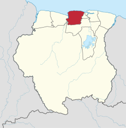
 Map of Suriname showing Saramacca district | |
| Country | Suriname |
| Capital | Groningen |
| Area | |
• Total | 3,636 km2 (1,404 sq mi) |
| Population (2012 census) | |
• Total | 17,480 |
| • Density | 4.8/km2 (12/sq mi) |
| Time zone | UTC-3 (ART) |
Saramacca is a district of Suriname, in the north. Saramacca's capital city is Groningen, with other towns and cities including Batavia and Boskamp.
Saramacca has a population of 17,480 and an area of 3,636 km².
The district has traditionally been the site of dozens of small, family owned farming communities, and it has only been recently that large agricultural projects have begun to emerge, primarily geared to the production of bananas and rice.
The district is known for its birds, with ornithologists and birdwatchers coming from all over the world to study and admire Saramacca's toucans, parrots and cocks-of-the-rock.
Saramacca is also the name of a group of Maroons who established communities along the Saramacca River having fled slavery.
Resorts

Saramacca is divided into 6 resorts (ressorten):

