
Selnica, Međimurje County
Selnica | |
|---|---|
Municipality | |
 Church of Saint Mark | |
 Selnica Location of Selnica in Croatia | |
| Coordinates: 46°29′N 16°23′E / 46.483°N 16.383°E | |
| Country | |
| County | Međimurje |
| Government | |
| • Municipal mayor | Ervin Vičević (HDZ) |
| Area | |
| • Municipality | 24.9 km2 (9.6 sq mi) |
| • Urban | 5.5 km2 (2.1 sq mi) |
| Population (2021)[2] | |
| • Municipality | 2,636 |
| • Density | 110/km2 (270/sq mi) |
| • Urban | 949 |
| • Urban density | 170/km2 (450/sq mi) |
| Time zone | UTC+1 (CET) |
| • Summer (DST) | UTC+2 (CEST) |
| Postal code | 40313 Sveti Martin na Muri[3] |
| Website | selnica |
Selnica (Hungarian: Szelence) is a village and municipality in Međimurje County, in northern Croatia.
History[edit]
In year 1334 Selnica was recorded as Catholic parish named Sancti Marci in Census of parishes of Zagreb Diocese.[4] Charter issued in year 1478 mentions villages Zenth Mark and Zelnycz.[5]
In the 1850s, oil was discovered in the Selnica. Exploitation of the two oil fields began in the late 19th century and lasted until the 1950s.[6]
Municipality of Selnica was established in year 1992.[7]
Geography[edit]
Selnica is located in part of Međimurje called Gornje Međimurje. Village of Selnica, municipality centre, is about 14 kilometres northwest from Čakovec, and some 100 kilometres north of Zagreb. The municipality covers an area of 24.84 km2.[8]
Geomorphologically, the municipality can be divided into two parts. The southern part consists of low hills called Međimurske Gorice, while the northern part consists of alluvial plain of the river Mur.
Demographics[edit]
In the 2011 census, the municipality had a population of 2,991 in 10 villages.[9] Selnica is experiencing slight population decline since the 1960s.
The majority of inhabitants are Croats making up 99% of population.[10]
|
| ||||||||||||||||||||||||||||||||||||
| [9][11] | |||||||||||||||||||||||||||||||||||||
Settlements[edit]
| Village | Population[9] (2011) |
|---|---|
| Bukovec | 174 |
| Donji Koncovčak | 303 |
| Donji Zebanec | 173 |
| Gornji Zebanec | 189 |
| Merhatovec | 157 |
| Plešivica | 115 |
| Praporčan | 182 |
| Selnica | 1,076 |
| Zaveščak | 245 |
| Zebanec Selo | 378 |
| TOTAL | 2.991 |
Culture[edit]
In Selnica is located the privately owned Oldtimer museum Šardi with collection of historic cars, motorcycles, tractors, and other vehicles.[12]
Gallery[edit]
-
 Old chestnut trees
 -
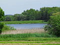 Artificial pond near Selnica
 -
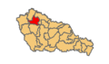 Location within Međimurje County
 -
 Village centre
 -
 Cross of Martin Špolarić
 -
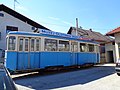 Oldtimer Museum ´´Šardi´´


References[edit]
- ^ Register of spatial units of the State Geodetic Administration of the Republic of Croatia. Wikidata Q119585703.
- ^ "Population by Age and Sex, by Settlements, 2021 Census". Census of Population, Households and Dwellings in 2021. Zagreb: Croatian Bureau of Statistics. 2022.
- ^ "Pretraživanje mjesta s pripadajućim poštanskim brojem". Hrvatska pošta (in Croatian). Retrieved December 2, 2020.
- ^ Vugrinčić, Benjamin (2015). Župe na području Međimurja u 14. i 15. stoljeću [Parishes in the Međimurje area during 14th and 15th century] (Thesis) (in Croatian). pp. 62–64. Retrieved October 5, 2020.
- ^ "8143". Hungaricana (in Latin). Retrieved November 29, 2020.
- ^ Mikolaj, Ksenija (2015). Nafta u Međimurju [Oil in Međimurje] (Thesis) (in Croatian). pp. 15–20. Retrieved December 3, 2020.
- ^ "2018 – Statistical Yearbook of the Republic of Croatia" (PDF). Croatian Bureau of Statistics. December 2018. p. 74. Retrieved December 3, 2020.
- ^ "PPUO Selnica – VI. ID" (in Croatian). Zavod za prostorno uređenje Međimurske Županije. April 2020. p. 21. Retrieved December 3, 2020.
- ^ a b c "Population by Age and Sex, by Settlements, 2011 Census: Selnica". Census of Population, Households and Dwellings 2011. Zagreb: Croatian Bureau of Statistics. December 2012.
- ^ "Population by Ethnicity, by Towns/Municipalities, 2011 Census: County of Međimurje". Census of Population, Households and Dwellings 2011. Zagreb: Croatian Bureau of Statistics. December 2012.
- ^ "Naselja i stanovništvo Republike Hrvatske". Croatian Bureau of Statistics. Retrieved 24 November 2020.
- ^ Keglević, Tomislav (July 26, 2020). "Obišli smo sve muzeje automobila u Hrvatskoj". Auto Press. Retrieved December 3, 2020.
Subdivisions of Međimurje County | ||
|---|---|---|
| Towns |
| .svg) |
| Municipalities | ||
Subdivisions of Međimurje County | ||
|---|---|---|
| Towns |
| |
| Municipalities | ||